Onehunga to Puhinui
-
Walking
Te Araroa trail section: Follow the once volcanic coast east of Māngere through a variety of terrain. You'll see birds, sewage works and old Māori garden mounds.
From the end of the Coast to Coast Walkway at Onehunga Bay Reserve head southeast through the reserve. Cross the four-lane Hugh Watt Drive on a foot bridge to Orpheus Drive.
Follow Orpheus Drive east along the Manukau foreshore until opposite the Airport Harbour View Motel.
The path rises to a junction where you turn right (south) onto the new pedestrian bridge, built alongside the abutments of the older Mangere Bridge that was replaced, partially demolished and now rebuilt for pedestrians, cycles and scooters
The piles of the old bridge were founded on a lava crust from nearby Māngere Mountain. Over the years, the bridge footings broke through the crust and sank slightly. Further damage from a ship collision led to its removal.
When the old bridge was closed to foot traffic, a pedestrian underpass was built under the newer motorway bridge a short distance further along the foreshore. That underpass is still there, but was scheduled for removal in December 2022
Once you've crossed the Manukau Harbour on the new pedestrian bridge, head west along Kiwi Esplanade.
Alternatively continue south another 250 m up to Mangere Bridge village to enjoy a range of cafes, including the highly recommended Hong Kong Bakery.
On Kiwi Esplanade, follow the coastal margin for 3km to Ambury Regional Park. Keep to the right through the gate to follow the marked grass track around the edge of the paddocks near the shore.
The grass track finishes through a gate to the access road for the Ambury Park campground. The basic campground has fresh water on tap, toilets and a barbeque. Bookings are recommended. The Ambury Regional Park headquarters, including a ranger’s house, are 250 m up the road.
Book online at Ambury Park Campground or 09 301 0101.
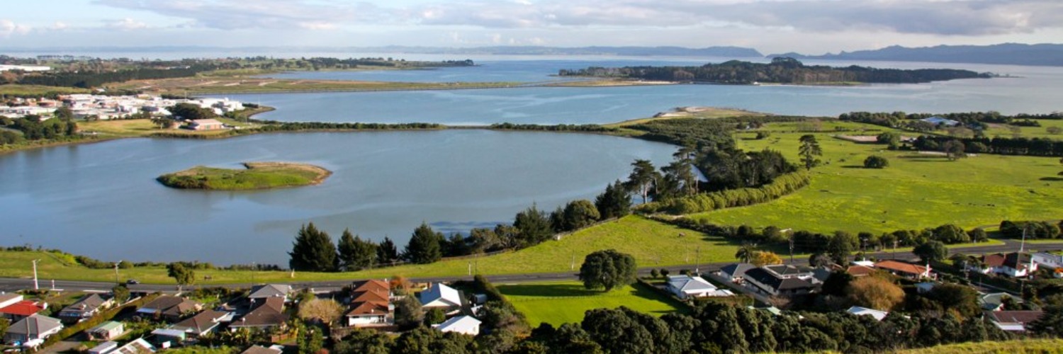
Māngere Foreshore Track - 9km / 2.5 hours
Exit through the kissing gates that mark the Ambury Regional Park’s southwest boundary. Cameron the draughthorse is the main resident on this stretch.
Beyond the kissing gates you’ll see the first signage of the Māngere Foreshore Track, opened in 2005 as part of Watercare’s Manukau foreshore rehabilitation.
There are several shellback bird roosting sites along the foreshore. The first bird hide is signposted from the Watercare track at km 610.8. A 330 m side track leads to a constructed bird hide with information boards, but the roosting site is no longer used. A 570 m shore path rejoins Te Araroa at km 612, where there is a viewpoint overlooking an artificial island used by South Island pied oystercatchers and royal spoonbills. The best roost site is another 0.6 km south. It is a peninsula fenced to prevent human access. A bench seat on a knoll provides a view point over the roost. The shellbanks host an array of bird species: godwits, lesser knots, wrybills, spoonbills and the distinctive red at-arms slope of the oyster-catchers' bright bills.
2.5km from the start of Watercares you pass the Māngere Lagoon, part of the Auckland volcanic field. In the 1960s, earthworks for the Māngere Sewage Works sludge ponds in the lagoon damaged the scoria cone at the centre of this explosion crater, and the crater itself.
The sewage works handled Auckland’s waste for 40 years. Its sludge ponds stood on this shore, and its oxidation ponds webbed the sea on the right-hand side of the track all the way out to Puketutu Island.
Walk on 1km and you’ll see version two of the old sewage works, Watercare’s Wastewater Treatment Plant, opened in 2003.
The new plant can process waste in 13 hours by using clarifiers and ultra violet radiation. The old plant used sludge settlement and oxidation, and took 21 days. These days, the sterile solids are trucked away, and the sterile fluids are released on the outgoing tide at the rate of 25 tonnes a second – Auckland's biggest river. As Watercare decommissions some of the old treatment systems, they have embarked on a project to rejuvenate the area and nurture the abundant birdlife. The Te Araroa track takes you around one of these areas.
Go past the main Watercare works and offices then turn right (west) next to the canal. Then turn again left (south) past the bird roost and continue past the restored area.
From the car park and toilets at km 616.8 follow the sign for Ihumatao Quarry Rd exit
Across the Oruarangi Creek pedestrian bridge, a wooden gate lets you onto a nicely gravelled path that leads past a bird hide, and past white-shell beaches. Some low-lying parts of the path may be muddy.
By now the Otuataua Stonefields are in sight. Volcanic vents once effervesced here, and Māori moved in later to trap the sun's warmth, piling up these stones and expanding the kūmara-growing season. The Māori garden mounds, the storage pits and the drystone walls of later Pākehā farmers are still prominent in this area. Various paths wind through the old remnants of a previous culture.
Watercare signage on this section is less than helpful and Te Araroa direction signs are faded and easily missed. A gps navigation app may be helpful in staying on the correct path through the coastal wetlands. The sign at km 617.5 is poorly placed. The path straight ahead leads to a view point with information signs explaining local history. Turn left, away from coast, for the Ihumatao Quarry Rd exit.
A second Watercare sign at km 617.8 is also unclear. The gravelled path ahead explores the shoreline but is not part of Te Araroa. For the Ihumatao Quarry Rd exit go through, or climb around, the galvanised gate opposite the sign and follow the grass track up the slope parallel to a line of trees.
From the Otuataua Stonefields, exit onto Ihumātao Quarry Road and follow southeast. There is a signposted avocado orchard near the end of the road and walkers are invited to sample a few in season.
Ihumātao Quarry Road has been the scene of political protest in recent years. There are are some signs of this remaining. There are vehicle road blocks around the intersection of Ihumatao Quarry Road and Oraurangi Road, but Te Araroa walkers are welcome to pass through. Please show respect for local sensitivities.
Turn right into Oruarangi Road, left (east) into Ihumātao Road for 3kms. Turn right/south into George Bolt Memorial Drive for 1km, and past the Airport Shopping Centre (and the Airport to the south). Turn left (east) into Tom Pearce Drive, and follow it for 1.5 km as it turns south. Turn left/east onto Puhinui Road and follow it for 3km. Turn right into Price Road. Follow Price Road for 1km down to Puhinui Reserve.
Northbound directions for Otuataua Stonefields
From George Bolt Memorial Drive turn left into Imumatao Road for 3 kms. Turn right (northeast) into Oruarangi Road. After 0.75 km walk past the road block and turn left into Ihumatao Quarry Road. At the end of the road (1 km) there is signage and a wooden gate. The route now follows a grass track to the right beside a row of pine trees. Cross a galvanised gate at the and of the track and turn right (northeast) onto the Watercare Coastal Walkway. At km 617.5 turn right (east) again and continue another 0.6 km to cross the Oruarangi Creek pedestrian bridge
Conditions
Track standard: Walking track
- Vehicles on road or track - take care crossing roads, especially around the airport
- Farming operations
- Open drains
- Track exposed to sun, wind or cold
How to get here
Northern Start: Onehunga Bay Reserve, Beachcroft Ave
Southern End: Puhinui Reserve, Price Road
Transport
Accommodation
Food And Supply
Track Elevation and Map

Total 1 photos. Click image above to view them all.
More information
Before starting Te Araroa either as a through-walker of the whole country or a section walker, please register on Te Araroa website. Please also visit the website or download the app for detailed maps, trail alerts and other relevant information.
We encourage you to continue gaining the skills and knowledge required for a safe trip. The NZ Mountain Safety Council has lots of free resources and information you can use. These can be accessed via www.mountainsafety.org.nz.
We recommend trying these online learning tools:
Additionally, check out the range of helpful videos available from the NZ Mountain Safety Council YouTube channel.

Page last updated: Apr 16, 2024, 4:58 PM