Photo by
Radek Strnad
The Tongariro Alpine Crossing track passes over varied and spectacular volcanic terrain. Trek across a volcanic alpine landscape of dramatic contrasts – steaming vents, glacial valleys, ancient lava flows, alpine vegetation and vivid crater lakes, all with stunning views. Be prepared for a long and challenging day out.
Tongariro National Park is a UNESCO dual World Heritage Area and was the first in the world to receive cultural World Heritage Status.
Note: Te Araroa track descriptions work from North to South whereas the Department of Conservation encourages trampers to walk the Tongariro Alpine Crossing in the other direction – from South to North. So be aware, the crossing is a very popular tramp and following these instructions, you will be going against the flow.
This challenging trip begins at 1120m. It climbs the Mangatepopo Valley to the saddle between Mount Tongariro and Mount Ngāuruhoe, through South Crater before climbing again to Red Crater, the highest point on the crossing at 1886m.
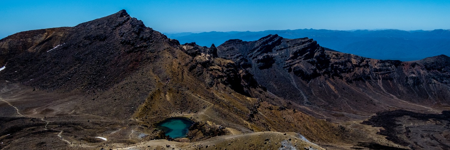
You will then descend on a volcanic rock scree track to the vivid Emerald Lakes, known as Ngarotopounamu (greenstone-hued lakes). After passing Blue Lake, also known as Te Wai-whakaata-o-te-Rangihīroa (Rangihīroa’s mirror), the track sidles around the northern slope of Tongariro, then descends in a zigzag track past the old Ketetahi Shelter site and down to the road end at 760m.
From the Ketetahi Road end, the track goes through a cool podocarp-hardwood forest which is a relaxed contrast to the coming long ascent to the old Ketetahi Shelter site. The track travels alongside a stream polluted with minerals from Ketetahi Springs and, at two points, passes over the tongue of a lava flow from Te Maari Crater.
From the forest bush line, the track winds its way up and up and up, through tussock slopes past the Ketetahi Springs to the old Ketetahi Shelter site.
From the old Ketetahi Shelter site, the track ascends further before sidling down around the flanks of North Crater to the Blue Lake and over the Mars-like Central Crater. Then it’s past the three water-filled explosion craters called the Emerald Lakes; their brilliant greenish colour is caused by minerals which have leached from the adjoining thermal area. The Tongariro Northern Circuit track to Oturere Hut branches off to the left at the lowest lake.
Taking care on the loose stones and gravel on the track as you ascend steeply to the summit of Red Crater (1886m), the highest point on the Tongariro Alpine Crossing. You can also smell the sulphur, evidence that Red Crater is still active.
The Tongariro Alpine Crossing track then continues along a poled route down the ridge leading to South Crater.
From Mangatepopo Saddle between Mount’s Ngāuruhoe and Tongariro, you can be rewarded, on a clear day, by views of Mt Taranaki to the west. Then it’s a steep descent to the head of the Mangatepopo Valley where a short side track leads to Soda Springs. The track then makes its way down the Mangatepopo Valley, at a gentle gradient alongside a stream and around the edges of old lava flows.
For Te Araroa through walkers, the turnoff to the Mangatepopo Track to Whakapapa is 200m further on from the Mangatepopo Hut sidetrack.
The carpark at Mangatepopo Road is 1km (15 minutes) from the Mangatepopo Track turnoff.
Mangatepopo Hut is free from 1st May to 20th October. From 21st October it is classed as a Great Walk and requires booking. Backcountry Hut passes are not useable
You need to be skilled and prepared to complete the Tongariro Alpine Crossing, especially during winter. An ice axe and crampons are essential, as is competency using them.
You will need to be skilled and prepared to complete the Tongariro Alpine Crossing, Northern Circuit and Round the Mountain tracks in winter. An ice axe and crampons are essential, as is competency using them.
Tongariro Alpine Crossing (Red Crater) weather - NIWA
No dogs, horses, guns or bikes. No drones.
How to tramp in winter: Tongariro Alpine Crossing | Tongariro Northern Circuit | Round the Mountain Track
There is very limited parking near the access points to the track. From the beginning of 26 October (Labour Day weekend) to 30 April, parking restrictions (4 hour maximum) are in place at the road-ends.
Excellent shuttle services run from all local towns - arrange through the following i-SITEs:
The Whanganui region starts at the carpark at the northern end of the Tongariro Alpine Crossing, 1km off SH 46, Tongariro National Park.
The Whanganui section of Te Araroa ends at Bulls. It is on Highway 1 so is well serviced by long haul buses, as above.
There are several shuttle companies providing morning pick-ups from nearby towns and delivery to the track start, such as National Park, Ōhakune, Tūrangi and Taupō. They include:
We recommend booking a shuttle as there is a 4-hour parking restriction at both Mangatepopo and Ketetahi Road ends.
For those taking a modified route, YHA Ōhakune Station Lodge is a 1906 historical villa located in the beautiful alpine town of Ōhakune, adjacent to the world-renowned Tongariro National Park. Guests enjoy the use of extensive facilities including shared and private rooms, full kitchen amenities and two lounges. During the brilliant Central Plateau summers, the outdoor woodfire pizza oven is fired up. Guests can enjoy friendly games of cricket or simply relax on the verandas overlooking the peaceful native gardens while taking in the views of Mt Ruapehu.
Please note that freedom camping at Ketetahi Road and Mangatepopo Road ends is not allowed.
Water from the upper Mangatepopo stream, Emerald Lakes and Ketetahi Springs is not suitable for drinking due to high mineral content. There is no drinkable water available between the head of the Mangatepopo Valley and Mangatepopo Hut. Respect the water supply at Mangatepopo Hut, as this is limited and is the supply for those staying at the Hut. Treat all water in the park.


Total 3 photos. Click image above to view them all.

2 years ago
Going up the summit over the Devil's staircase, to the lakes, the track was well maintained, however, on the way day, the long and winding track was often in disrepair in a lot of places. It needs some attention going down to Ketetahi. I did enjoy the walk, though, and what an accomplishment.