
Forestry
There are several reasons for foresters to be aware of and understand public access instruments.
These include to:
- Understand legal responsibilities and implications
- Avoid negative publicity
- Maintain good community relationships
- Understand and manage recreational expectations
- Identify points of entry to forests
- Assist management of risks such as health and safety or fire
The main instruments are roads, marginal strips, and public access easements. A complete list of the most likely instruments is attached as Appendix A.
Roads
Roads provide the public with the right of free passage. There is no difference in the legal rights of members of the public to use unformed legal roads, colloquially referred to as ‘paper roads’, and formed roads maintained by councils (or NZTA.)
Local territorial authorities, such as district councils, are responsible for administering legal roads other than state highways.
Legal roads are separate parcels of land. This means that unformed legal roads (ULRs) are not ‘over’ or ‘across’ a title, but the road parcel may intersect or dissect a title.
The Local Government Act 1974 specifies that:
- Roads, other than state highways, are vested in the local council (s316)
- Roads are under the control of the local council (s318)
- Council may permit the erection of a swing gate or cattle-stop where it is not practicable or reasonable to fence the road (s344)
- Every person commits an offence who erects an unauthorised fence or other obstacle or work on a road (s357).
Neither the council as the statutory owner of the road nor the adjoining owner as de facto occupier may exclude anyone else from using the road. Under the Summary Offences Act 1981 (s 22), it is an offence to obstruct a public way.
Legal roads, often ULRs, provide legal public access adjoining or through many properties. For example, see Map 1 below.
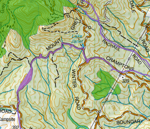
Map 1: Unformed legal roads intersecting property (for example, Ashley Forest, Corisol NZ Ltd)
ULRs can also provide public access alongside waterways associated with many properties. For example, see Map 2 below.
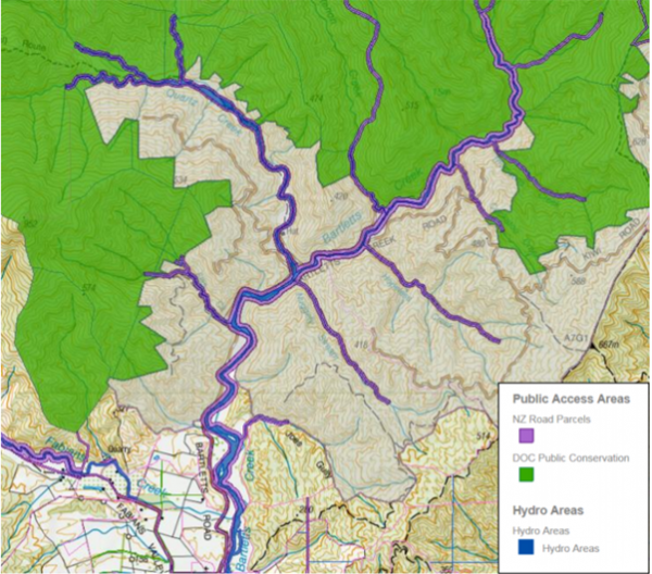
Map 2: Unformed legal road riparian access (for example, Bartletts)
ULR are fixed parcels and therefore do not move with the associated water body, which can mean that there may be a physical separation between the public access and the actual water body.
Marginal Strips
Marginal strips are 20m wide strips of public conservation land (Part 4A, Conservation Act 1987) that may adjoin waterways. They have been reserved from sale when Crown land has initially been sold. Two of their purposes are to enable public access to adjacent watercourses (or bodies of water) and public recreational use. The Department of Conservation is responsible for marginal strips.
Many properties have public riparian access by way of marginal strips. Some have been surveyed and are recorded in the cadastre. For example, see Map 3 below.
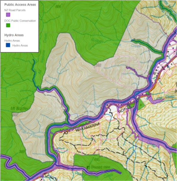
Map 3: Marginal strip riparian access (green alongside waterways) (for example, Wilsons Construction, OneFortyOne Plantations, shaded grey)
However, many marginal strips are not recorded in the cadastre, and a title search is required to verify whether or not the title is “Subject to Part IVA Conservation Act 1987”. For example, see figure 1 below.
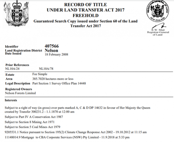
Figure 1: RT 407566, now OneFortyOne Plantations
Where a title is annotated as above, any waterway with an average bed width greater than 3 metres has a 20m marginal strip adjoining it. To determine whether a waterbody has such a marginal strip technically requires a surveyor to determine the bed’s average width using guidelines from DOC. However, it may be obvious in many cases.
Marginal strips created under the Conservation Act 1987 are moveable marginal strips that move with the waterbody’s boundary. Marginal strips created under previous legislation (principally the Land Act 1948) and held under Section 24(3) Conservation Act 1987 are fixed marginal strips and may not necessarily now adjoin the relevant waterbody.
Public Access Easements (PAE)
Before Crown forest lands, Crown forestry assets, or Crown forestry licences were sold, and generally to protect existing public access arrangements, many PAEs were created under the Crown Forest Assets Act 1989. The responsible Ministers for the Act are the Minister for State Owned Enterprises and the Minister of Finance, with Land Information New Zealand being responsible for the administration of Crown forestry licences. The Department of Conservation has generally been the agency ‘on the ground’ for PAEs.
The purpose of PAEs is to permit and allow access by the public over and across the identified land, constrained by the perceived needs of the forestry operator. The PAE documents generally provide that the owner may close or otherwise restrict the use of the access during the hours of darkness for reasons relating to the safety of those using the access or those working on the land and for reasons relating to the protection of the trees, buildings, plant, equipment and related items on the land. The owner is not required to maintain any road, track or other access way the PAE may be over, when it is not required for their use.
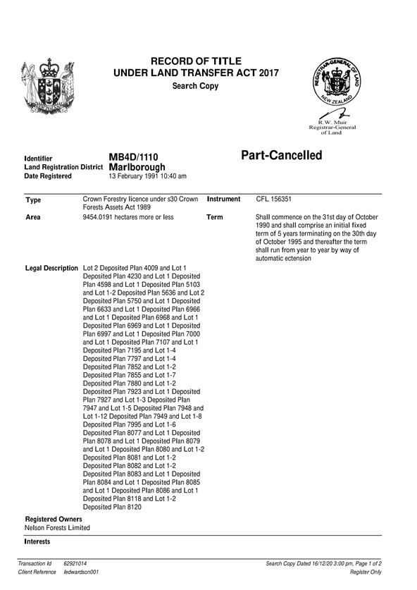
All PAEs have been depicted on survey plans. For example, see figure 2 below and registered on records of title as an interest. An example of a record of title for a Crown Forestry Licence is attached as appendix B.
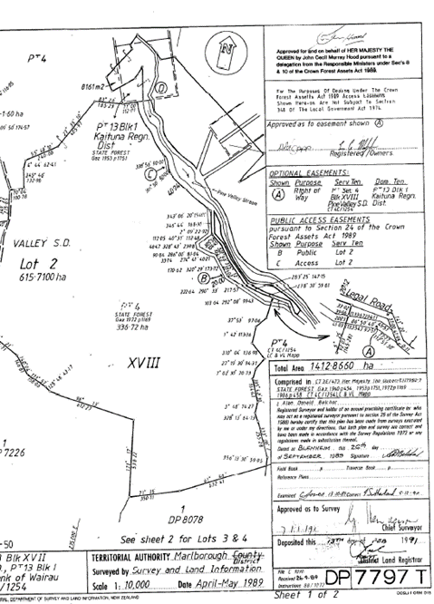
Figure 2: Part DP 7797, showing PAE ‘B’ and ‘C’ (PAE 3 Pine Valley, OneFortyOne Plantations).
The above PAE is an example of one depicted in the cadastre and represented spatially (highlighted pink) as shown on map 4 below.
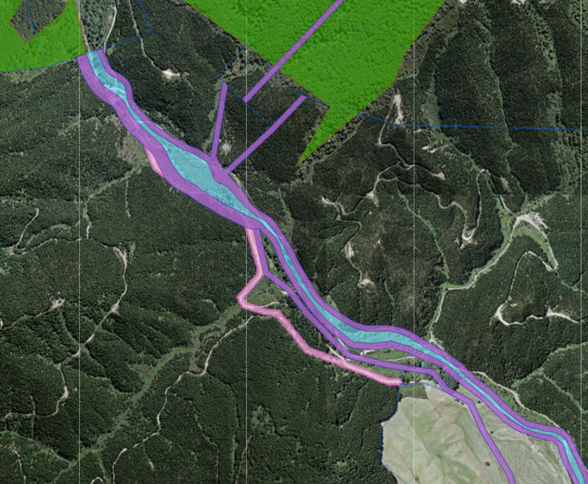
Map 4 shows PAE that has been depicted in the cadastre (highlighted pink) (PAE 3 Pine Valley, OneFortyOne Plantations).
However, many PAEs have not yet been entered into the cadastre and therefore have no spatial representation.
Conclusion
Forest managers need to be aware of public access that may be associated with forestry blocks to
- Understand legal responsibilities and implications
- Avoid negative publicity
- Maintain good community relationships
- Understand and manage recreational expectations
- Identify points of entry to forests
- Assist management of risks – such as health and safety or fire
There can frequently be apparently conflicting interests between the public seeking access rights for tramping or mountain biking, for example, and forest managers with legitimate concerns regarding fire risk and health and safety, especially during planting and harvesting. Many conflicts can be perceived rather than real, and many others can be mitigated by appropriate consideration and compromise. Precise and accurate signage can be an effective tool to mitigate potential conflicts. A good example is one recently implemented by OneFortyOne Plantations in Nelson. For example, see figure 3 below.
Herenga ā Nuku works with many forestry companies to help them understand their legal obligations, enable appropriate public access and mitigate potential risks wherever possible.
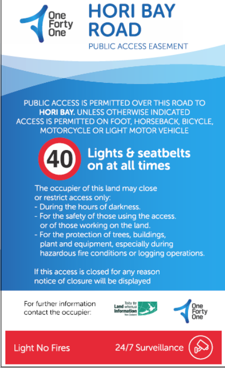
Figure 3: OneFortyOne Plantations signage on a PAE.
Appendix A: Principal Forms of public access that may be associated with forestry blocks
Legal form |
Characteristics |
Security of access |
Underlying ownership |
Administering agency |
Relevant statutes |
|
Roads |
The common law right implicit in the concept of a public “highway” and controlled by local authority or Government agency (may be closed for limited periods) Local bylaws may restrict vehicle access. |
Highest
|
Local authority, or Crown for Government roads, including State Highways |
Local authority or Government Agency |
Local Government Act 1974; Government Roading Powers Act 1989 Land Transport Act 1998; Public Works Act 1981 |
|
Marginal strips |
Statutory right along some water margins. New strips are movable. It may be temporarily closed. Riparian access created under the Land Act, which has fixed boundaries.
|
High |
Crown |
Department of Conservation |
Conservation Act 1987
Land Act 1948 |
|
Esplanade reserves |
The statutory purpose of public access subject to conservation restraints. Fixed boundaries. |
High. Subject to administrative constraints for conservation purposes |
Territorial authority |
Local authority |
Resource Management Act 1991 |
|
Esplanade strips |
The statutory purpose of public access subject to conservation restraints. Movable boundaries. It may be temporarily closed. |
The statutory right is subject to easement conditions; May be modified by an agreement between the landowner and the local authority |
Private land subject to access easement in gross |
Local authority |
Resource Management Act 1991 |
|
Access strips |
The statutory purpose of public access is usually urban pedestrian. It may be temporarily closed. |
The statutory right is subject to easement conditions. It may be modified by an agreement between the landowner and the local authority.
|
Private land subject to access easement in gross |
Local authority |
Resource Management Act 1991; Land Transfer Act 1952 |
|
Gazetted Walkways |
Statutory right of walking access; Other forms of access discretionary It may be temporarily closed.
|
High. Statutory right of walking access; other forms of access discretionary |
Public land or private land subject to an easement in gross |
DOC, local authority or other controlling authority appointed by Herenga ā Nuku. |
Walking Access Act 2008; Land transfer Act 1952; Land Transfer Regulations 2002 |
|
Public Access Easement (over Land subject to the Crown Forests Assets Act) |
Walking access and some vehicle access subject to safety and security restrictions |
Access subject to the application and administration of the safety and security exception by the owners of the cutting rights |
Crown or private land subject to easements once disposed to Treaty of Waitangi claimants |
Licensees (or their delegates) until the expiry of the licences. Then the underlying land owners. |
Crown Forests Assets Act 1989; Treaty of Waitangi settlement acts |
|
Other public access easements in gross created by agreement |
May provide public access; grantee may be DOC, LINZ, Herenga ā Nuku, a local authority or someone else. The grantee may be liable for acts by the public. |
It may be modified or cancelled by agreement between the parties. |
Public land or private land subject to an easement in gross. |
Parties to the easement; may include DOC, LINZ and Herenga ā Nuku. |
Conservation Act 1987 Land Act 1948 Land Transfer Act 2017; Land Transfer Regulations 2018; Some Treaty of Waitangi settlement Acts |
|
Access easements |
Access rights that run with the dominant tenement. Access available to the owners of the dominant tenement and their invitees. |
Restricted to the dominant tenement and their invitees. It may be modified or cancelled by agreement between the parties. |
Private land subject to an easement |
Parties to the easement subject to statutory requirements |
Land Transfer Act 2017; Land Transfer Regulations 2018 |
|
Crown-owned riverbed |
Public access is usually not opposed by the Crown |
Secure subject to identifying relevant riverbed and subject to Crown’s discretion |
Crown |
Land Information New Zealand |
Land Act 1948; Coal Mines Amendment Act 1903 |
|
Other Crown-owned lands |
Public access is usually not opposed by the Crown if compatible with the purpose for which the land is held. |
Secure where not restricted by statute; subject to the discretion of the Crown |
Crown |
Administering Government department or if unallocated Land Information New Zealand. |
Land Act 1948; Public Works Act 1981 Various other statutes may apply |
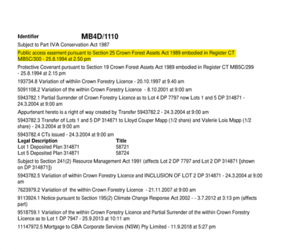
Appendix B: Example of record of title for Crown Forestry Licence with PAE highlighted yellow
Written by Geoff Holgate