
Unlocking the potential of tactical urbanism for active transport promotion in Auckland
Unlocking the potential of tactical urbanism for active transport promotion in Auckland
Declan Weir
A dissertation submitted in partial fulfillment of the requirements for the degree of Bachelor of Urban Planning (Honours) at the University of Auckland 2019. Research sponsored by the New Zealand Walking Access Commision.
Abstract
Active transport is widely recognised as a critical strand in the transition to a more sustainable, healthy, friendly and equitable urban society. However, it is only viable in urban areas with appropriately planned streets and infrastructure that make travel safe, comfortable and pleasant. Auckland’s transport planning has historically been dominated by a concern for traffic flow and private cars, over active modes. This has materialised as a street network offering little safety, comfort or appeal for those outside cars, as reflected by low rates of walking and cycling. Despite a strong mandate for change amidst the climate crisis and strategic will to see an increase in active transport, the conventional tools and approaches within Auckland’s planning framework have failed to act on the ground quickly. However, there is a solution. Both overseas and in Auckland, some of the most innovative ideas for people- centric streets and active transport infrastructure are coalescing as ‘quick, cheap and light’ tactical urbanism interventions. This approach has a demonstrated propensity for overcoming the intransigence of conventional planning and delivering immediate improvements to walking and cycling infrastructure networks; offering significant promise for modal shift in Auckland. This research, therefore, aims to answer the question of how tactical urbanism can be supported as a tool to improve walking and cycling infrastructure and promote active transport in Auckland.
To address this research question, a two-phase research strategy was developed combining qualitative techniques common to urban research. The first phase comprised a desktop evaluation of Auckland’s existing transport planning framework, including strategic documents, regulations and institutional structures. This evaluation sought to identify barriers within Auckland’s planning framework that reduce tactical urbanism’s viability within transport planning. The second phase presents four case studies, analysed to demonstrate the impacts of varying planning frameworks on the success of tactical urbanism in improving walking and cycling infrastructure.
The research findings highlight that Auckland’s current framework presents significant regulatory and institutional barriers to the use of tactical urbanism as tool for developing improved walking and cycling infrastructure; a finding enforced through the analysis of two local case studies. International case studies set an example for Auckland, demonstrating that changes can be made to the framework to support tactical urbanism – streamlining the approach for city planners and community actors alike. Ultimately, with changes to ensure better support for tactical urbanism, it’s full potential could be unlocked and the city could finally begin to see a transition to a more sustainable, healthy and friendly transport network.
Acknowledgements
I would like to acknowledge the New Zealand Walking Access Commission for their generous sponsorship of this research.
Thanks are also due to Dr Dushko Bogunovich, University of Auckland; Claire Davis, Auckland Design Office; and Kathryn King, New Zealand Transport Agency (formerly Auckland Transport), who each provided valuable input at various stages of this research.
Dedication
To my generous and faithful family. It took a village.
“If I have seen further than others, it is by standing on the shoulders of giants”
List of Abbreviations
|
AC |
Auckland Council |
|
ADO |
Auckland Design Office |
|
AT |
Auckland Transport |
|
CAS |
Crash Analysis System |
|
CCO |
Council Controlled Organisation |
|
CoPTTM |
Code of Practice for Temporary Traffic Management |
|
LGOIMA |
Local Government Official Information & Meetings Act (1987) |
|
NGO |
Non-Governmental Organisation |
|
NIMBY |
Not in my back yard |
|
NZ |
New Zealand |
|
NZTA |
New Zealand Transport Agency |
|
RCA |
Road Controlling Authority |
|
RLTP |
Regional Land Transport Plan |
|
TCD |
Traffic Control Devices |
|
TCGSG |
Traffic Control Devices Steering Group |
|
TMP |
Traffic Management Plan |
|
USRDG |
Urban Streets & Roads Design Guide |
1.0. Introduction
Active transport is widely recognised as a critical strand in the transition to a more sustainable, healthy, friendly and equitable urban society. It is widely acknowledged that increasing walking and cycling in urban areas can reduce congestion, improve liveability, enhance public health and reduce carbon emissions (Pooley et al. 2011; Zhao et al., 2018; Koglin, 2015). Amidst the climate emergency, rapid urbanisation, population growth, social inequality and a crisis of democracy, active transport is attracting considerable interest as an important instrument for ameliorating complex urban issues.
The street sits at the heart of active transport. It is the lifeblood of the urban transport system and central to the relationship between people and transport modes. People-centred streets empower pedestrians and cyclists to feel safe, comfortable and well connected (Global Designing Cities Initiative & National Association of City Transport Officials, 2016). Without appropriate street design and infrastructure, active modes do not flourish (Pucher & Buehler, 2008; Pfleider & Dietrich, 1995).
Since the 1950s Auckland’s transport planning and street design has primarily focused on the private car, with minimal investment made in efforts to promote active modes (Faherty & Morrissey, 2014). The result is a city-wide network of streets with wide traffic lanes, narrow paths and physical design that valorise the dominance of cars and marginalise pedestrians and cyclists. This has resulted in a car-centric system that entrenches unsustainable transport patterns. While active transport has thrived in international cities such as Copenhagen and Amsterdam with strong planning and investment, Auckland’s has dwindled with neglect (Pucher & Buehler, 2011). Currently just 8% of Auckland commuters walk or cycle, with car use significantly increasing its modal share between 1988 and 2014 (Manic et al., 2019). This is despite one third of Auckland’s car trips being within a walkable distance, and two thirds within a cyclable distance (Manic et al., 2019).
Despite broad recognition of active transport’s benefits, strategic will and a clear mandate to reform Auckland’s transport system to one that is more sustainable in nature, progress is slow. Auckland is still working under regulations, transport planning approaches, public involvement processes, and infrastructure programs that were established in response to the demographic, economic and socio-cultural trends of a different era (Lyndon & Garcia, 2011, p66). Indeed, the transport planning outcomes in the city still arc toward low-density, car dependent development. This is fuelled by a planning framework and regulatory apparatus that is resistant to change; and
“the layers of bureaucracy that must be navigated for projects small and large have become so thick and the process of receiving permission to build so convoluted, given the variety of competing interests and jurisdictions, that it is exceedingly difficult - and expensive - to get anything done efficiently, if at all.” (Lyndon & Garcia, 2011, p. 83).
This is not the future of the city. Auckland must now make the changes required to see a rapid modal shift and close the gap between the promises of people-centric streets and the delivery on-the-ground. Particularly with public demand running well ahead of official supply (Auckland Council, 2018). This change will require institutions and regulations that support people-centric policies, innovative planning approaches and methods of infrastructure provision (Regional Land Transport Plan; Manic et al., 2019).
Tactical urbanism is an approach that aims to recover and reallocate street space through quick, cheap and light interventions that demonstrate the possibility of long-term, large scale change. Recently, some of the most promising, innovative and dynamic ideas for urban improvement have been coalescing as tactical urbanism.
While tactical urbanism overcomes many of the traditional challenges of active transport infrastructure provision, including NIMBYism, sociocultural reluctance to change and budgetary constraints, it is instead confronted with a different suite of challenges relating to policy, regulation and bureaucracy. These challenges for tactical transport infrastructure improvements, both council and citizen-led, are a significant issue in Auckland’s planning discourse. The current framework renders attempts at tactical, quick-build projects slow, costly and bureaucratic. Auckland’s planning authorities have not made changes to regulations or institutions that could unleash the full potential of tactical urbanism for the city’s transport system. With several projects already successfully implemented, the demand for these quick and cheap improvements is set to only increase. Indeed, this is a trend that has been observed internationally in cities such as Bogota, Melbourne, New York and San Francisco.
The aim of this research is to assess the potential of tactical urbanism as a tool for active transport promotion within Auckland and identify measures that can support tactical urbanism to overcome barriers within the existing planning framework. This aligns with Priority 88 of the 2018 Government Policy Statement on National Land Transport, stating that “the government will investigate any regulatory barriers to the uptake and delivery of public transport, walking and cycling in New Zealand” (p.88).
It is important to acknowledge that this investigation is focussing on tactical urbanism within the transport planning framework. How tactical urbanism can be practically designed to provide better active transport infrastructure falls outside of the scope of this dissertation. In addition, the literature is clear that many measures including compact urban form, education and financial incentives must be integrated to increase the modal share of active transport. For reasons of space, this dissertation will focus solely on one tranche of active transport promotion, being the provision of walking and cycling infrastructure.
Research Question
Ultimately this context led to the following research question:
How can tactical urbanism be supported as a tool to improve walking and cycling infrastructure and promote active transport in Auckland?
Objectives
- Identify the benefits of active transport in theory and outline the characteristics of tactical urbanism that render it an effective tool for improving active transport
- Identify barriers to tactical urbanism’s implementation within Auckland’s existing transport planning framework, and highlight methods for better integrating tactical urbanism within Auckland’s mainstream planning practice.
- Evaluate the success of tactical urbanism case studies in practice for improving walking and cycling infrastructure both overseas and in Auckland, highlighting the impact of the planning frameworks on
Dissertation Outline
This dissertation is divided into eight chapters. Following this introduction, the second chapter gives a brief overview of the literature pertaining to active transport, improving walking and cycling infrastructure and the tactical urbanism approach. Both key terms ‘active transport’ and ‘tactical urbanism’ will be defined and their respective benefits identified. The methodological approach used to collect information and select case studies for this investigation is outlined in Chapter 3. In the fourth chapter, strategies, regulations and institutions that currently exist within the Auckland transport planning framework will be evaluated. In the next chapter, two Auckland case studies and two international case studies are presented, with findings from these briefly summarised. Chapter 6 will discuss the implications of the research findings, identifying barriers to tactical urbanism and drawing conclusions on how these can be overcome to better support active transport. Recommendation are subsequently drawn from this discussion in the seventh chapter.
2.0. Literature Review
2.1. Literature Search Structure
In investigating the research question, this literature review is broken into three distinct sections. The first section is an overview of the literature pertaining to active transport, the benefits of walking and cycling and corresponding infrastructural issues. This is followed by an examination of tactical urbanism, it’s benefits and role within planning. Each topic is subsequently combined in the final section, where the synergies between both are highlighted, laying a foundation for the analysis in subsequent chapters.
2.2. Active Transport Literature
2.2.1. Active Transport Definition
‘Active transport’ is a term for travel modes which require physical effort and are neither motorised nor carbon-dependent. This can include walking, cycling, running, rollerblading, skateboarding and scootering. For the purposes of this dissertation, the term ‘active transport’ will be used to refer solely to walking and cycling.
2.2.2. Active Transport in the Urban Transport System
The private car is an embedded and necessary mode of urban transport that increases mobility, opportunity and convenience. However, an increasing number of studies highlight the negative impacts of cars for emissions, air quality, socialisation, public health and active transport (Nieuwenhuijsen & Khreis, 2016; Nielsen, 2013). As car-dependency has ascended in many western cities, the rates of active transport use for everyday mobility have declined significantly (Faherty & Morrissey, 2014; Speck, 2012). Faherty & Morrissey (2014) contend that this decline has, since the 1950s, been facilitated by urban planning practices that support car-oriented street design and the separation of urban functions. Most urban form is now designed to prioritise vehicle efficiency over concerns for people, with reduced connectivity, marginal road safety and increased sprawl (Yeung et al. 2008; Gehl, 2010). These physical conditions are hostile to safe, quick and comfortable journeys for pedestrians and cyclists, rendering car travel more convenient and proliferating automobile dependence.
Interdisciplinary literature highlights that the current levels of car dependence are unsustainable and require a rapid modal shift – substituting vehicle travel with walking and cycling (Ben-Joseph, 1995; Faherty & Morrissey, 2014; Mandic et al., 2019). This promotion of active transport, requires a revaluation of “the attitudes towards car use so that where the distance and journey permits, walking and cycling are seriously considered” (Pooley, 2011, p.176). This is not complicated, but can be a highly sensitive planning issue in car-dependent cities where safety, cultural and environmental factors all present barriers to the wider uptake of walking and cycling modes; and where getting in a car is perceived to be the quickest and easiest mode of travel (Sadik-Khan, 2016; Pooley et al., 2011).
2.2.3. Benefits of Active Transport
Many studies have been published on the benefits of walking and cycling, highlighting the following attributes.
- Sustainability
Active transport is environmentally sustainable for two key reasons; first, it reduces dependence on non-renewable energy resources; and second, it does not directly generate greenhouse gas emissions or air pollution, both important contributors to climate change. Recent evidence demonstrates the substitution of car trips with walking and cycling is a strong tool for emissions reductions of up to 5%, or 150g of CO2 per kilometre (Neves & Brand, 2019; Harms & Kansen, 2018). This is supported by research showing that “bicycle access is negatively correlated with CO2 emissions from motorised travel” (Brand, 2013); “energy expenditure from walking is negatively correlated with fossil fuel use from car driving” (Frank et al., 2010) and “individuals in more ‘walkable’ neighbourhoods travel fewer vehicle kilometres” (Frank et al., 2007; Neves & Brand, 2019). Active transport promotion is, therefore, an important mechanism for achieving the Paris Agreement emissions target of 30% below 2005 levels by 2030 (Ministry of Transport, 2019; de Nazelle et al., 2010, Maibach et al., 2009).
- Health & Wellbeing
The link between sedentary behaviour and subpar health outcomes was first reported by Morris et al. in 1953. They found that physically active bus conductors had a reduced risk of developing coronary heart disease, relative to sedentary office workers. Since this time, a growing body of research has found that active transport is one of the most effective interventions for increasing physical activity and improving health outcomes across the life course (Rissell & McCue, 2014; Mandic et al., 2019; Haskell et al. 2009). Recent evidence [Mandic et al., 2019] reveals that increased walking and cycling can reduce the risk of obesity and non-communicable diseases such as stroke, type 2 diabetes, cardiovascular disease and certain cancers. This meta-analysis also found evidence of regular physical activity reducing the risk of depression, anxiety and dementia. Researchers underline that these health benefits occur regardless of age, gender, ethnicity or social status.
- Economic
The economic benefits of active transport are manifold. Firstly, a greater walking and cycling modal share reduces car-related costs, such as roading infrastructure provision and ongoing fuel costs for private users (Speck, 2012; Pucher & Buehler, 2008). Joe Cortright evidences this in his 2007 report ‘Portland’s Green Dividend’, calculating that the economic savings of Portland’s walking and cycling dominated mobility are more than $1.1 Billion USD each year (1.5% of all personal income earned in the region). Further, while the average American family spends one in five dollars on fuel and transport, this figure is just one in ten in Portland (Speck, 2012).
Secondly, increases in pedestrian volumes are positively correlated to increases in the footfall of local businesses and consumer spending. Indeed, Lawlor & Tasker (2018) highlight studies showing that pedestrians spend up to six times more than consumers who arrive by car, driving demand for local goods and services.
Finally, there is evidence that the provision of high quality active transport options is a key step in attracting strong talent, investment and jobs. In Portland between 1990 and 2000, the number of college educated working professionals aged between 25-35 increased five times faster than the national average (Cortright, 2007), with the city now home to over 1200 technology companies (Speck, 2012). Urbanist Chris Leinberger claims that “all of the fancy economic development strategies… do not hold a candle to the power of a great walkable urban place” (2008, p. 170).
- Social Equity
Researchers also describe walking and cycling as the most equitable modes of transport. The World Health Organisation (2019) attributes this to the affordability and accessibility for all income groups, particularly “the poorest urban sector who often cannot afford private vehicles”. However, active transport mobility is also a valuable tool for overcoming gender and age disparities, with women in The Netherlands representing 55% of all cycling trips and the citizens between 65-75 riding an average of 3.8km per day (Pucher & Buehler, 2008; Harms & Kansen, 2018). This facilitates improved public health, access to healthcare and education, increased social interactions and removes barriers to economic participation (Mandic et al., 2019).
2.2.4. Active Transport Infrastructure
Fundamental to active transport promotion and a reduction in car dependence is the planning and development of safe and well-connected walking and cycling facilities. Indeed, “aesthetically pleasing and practical pedestrian cycle paths have been clearly shown to increase physical activity and make active travel a more attractive proposition” (Rissel & McCue, 2014, p.155; Raine et al, 2012). In particular, the connection of utilitarian origins and destinations with strong facilities encourages walking and cycling for daily trips, beyond just recreation. Conversely, Pucher & Buehler (2008) found that the biggest deterrent to walking and cycling was street networks that made journeys unsafe, inconvenient or infeasible, in turn increasing perceived/socio-cultural barriers to a modal shift (p. 523).
In her ground-breaking transdisciplinary paper of 2005, Alfonzo developed the socio- ecological model of active transport, seeking to understand the needs of pedestrians and factors influencing their choice of mode. She lists five key needs: feasibility, accessibility, safety, comfort and pleasurability. These findings are transferable to cycling, and can each be addressed through the improvement of infrastructure and people-centric street design (Marqués & Hernández-Harrador, 2015). This is best exemplified by The Netherlands who, in response to the harmful effects of inexorable car use in the 1970s, undertook a significant reversal of their transport and land use policies to favour active modes. This included the introduction of “considerable alterations to the streets…such as road narrowing, raised intersections and crosswalks, traffic circles, extra curves and zig zag routes, speed humps and artificial dead ends” (Pucher & Buehler, 2008, p. 514). The Dutch bikeway network also more than doubled between 1976 and 1996, to 18,948 kilometres of protected lanes. The cumulative result of these improvements was an 81% fall in the pedestrian and cyclist fatality rate from 1978 to 2006, a four-fold increase in the cycling modal share and 36% increase in the kilometres cycled per inhabitant (Pucher & Buehler, 2008).
Based on the European experience, Pucher and Buehler (2008, p. 512) and Pooley et al.
(2011) recommend key infrastructural improvements for active transport promotion as follows:
- Extensive systems of fully-segregated, well-connected cycling facilities
- Modification of intersections to prioritise and protect cyclists
- Traffic calming measures (that slow, regulate or exclude traffic), particularly on routes without segregated paths
- Safe and convenient pedestrian crossing points
- Pedestrian routes that are welcoming, including paths of a sufficient width
However, researchers and practitioners alike commonly acknowledge the challenges of retro- fitting existing urban streets to better serve pedestrians and cyclists. A growing body of international best practice design guides including NACTO’s ‘Global Street Design Guide’ address these challenges by recommending modern street design improvements.
2.2.5. Challenges for Active Transport Infrastructure Planning
A city’s planning for improved walking and cycling infrastructure sits at the complex interface of institutional structures, political will, transport policy, planning approaches, strategies and regulation (Zhao et al., 2018; Nieuwenhuijsen & Khreis, 2016). Consequently, there are many barriers that can reduce the potential of walking and cycling infrastructure once implemented, or “even make implementation impossible” (Rietveld & Stough, 2005). The six categories of barrier identified by Banister in Rietveld & Stough (2005) are; resource barriers (lack of financial or physical resources); institutional barriers (problems with co-ordinated actions between organisations responsible); social and cultural barriers (public acceptability of measures); regulatory barriers (if implementation is complicated, or even made impossible by regulations or statutory requirements); side effects (collateral implications of implementation); and physical barriers (space restrictions). These can be prohibitive in the planning process and have significant cumulative effects for active transport uptake within cities.
2.2.6. Active Transport in Auckland, New Zealand
The challenges are particularly acute in Auckland, where historic transport policy bias has favoured investment in road construction over active modes, resulting in a one-dimensional system with entrenched unsustainable commuting patterns (Jakob et al. 2006, Faherty & Morrissey, 2014).
According to the Ministry of Transport, between 1988 and 2014, rates of walking and cycling continued to decrease, with rapid growth in the number of kilometres’ driven by Aucklanders since 2013. By contrast, the New Zealand Household Travel Survey 2015-2017 found that on an average day, 81% of New Zealand adults report no walking for transport and 98% reported no cycling for transport. The average time that New Zealand adults spent walking for transport has also decreased from 10 minutes per day to 8 minutes per day (Manic et al., 2019).
2.3. Tactical Urbanism Literature
2.3.1. Tactical Urbanism Definition
The academic literature related to tactical urbanism is modest, as it is still in its infancy. However, this is not reflective of its popularity. Indeed, tactical urbanism is a burgeoning city building technique that has attracted the attention of urban practitioners globally in recent years. In their seminal book of 2011, Lyndon & Garcia coin the term ‘tactical urbanism’, defining it as an “approach to neighbourhood building and activation that uses short-term, low- cost, and scalable interventions to catalyse long term change” (Lyndon & Garcia, 2011, p. 2). The approach seeks to make change on the ground quickly and cheaply, to tangibly demonstrate the potential of urban space. It applies a more open and iterative development process that unleashes innovation, uses resources efficiently and circumvents the traditional intransigence of planning processes (Lee & Millstead, 2013). The approach shares some similarities to other popular approaches including ‘guerrilla urbanism’, ‘DIY urbanism’ and ‘urban acupuncture’. However, the focus of this research will be solely tactical urbanism.
2.3.2. Tactical Urbanism Context
There are several core issues briefly highlighted in this section to establish the relevance of tactical urbanism for planning.
Globally, the need for innovative urban improvements is being driven by intensifying urban populations, disconnect between people and government, climate change, the rise of the internet and growing economic disparity. To respond appropriately, there must be changes to the structure of urban governance and the type of work that they are equipped to perform (Pfieffer, 2013). Tactical urbanism represents a response to this challenge. The approach was conceived from a frustration with systematic rigidities and bureaucratic systems within planning that stymied meaningful on-the-ground change, instead favouring “expensive ways to discuss the possible, with implementation perpetually on hold until a time when politics and dollars might align” (Lyndon & Garcia. pg xvi). Indeed, Mayor Lerner of Curitiba, Brazil famously contended that:
...the lack of resources is no longer an excuse not to act. The idea that action should only be taken after all of the answers and the resources have been found is a sure recipe for paralysis. The planning of a city is a process that allows for corrections; it is supremely arrogant to believe that planning can be done only after every variable has been controlled. (Lyndon & Garcia, 2011, p.1)
2.3.3. Characteristics of Tactical Urbanism
The term ‘tactical urbanism’ covers a range of activities on a spectrum of legality, ranging from government-led, sanctioned interventions to unsanctioned individual or community actions (refer to Figure 1). Lyndon & Garcia (2011, p. 12) identify three of the most common uses; those initiated by citizens to bypass the conventional planning processes; use by city government, developers, or NGOs for engagement and consultation; and by cities and developers to implement ideas quickly and test projects before a long-term investment is made.
Figure 1: Tactical Urbanism Spectrum
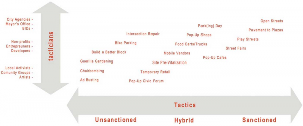
Source: Lyndon & Garcia, 2011
Lyndon and Garcia (2011) argue that the dynamic nature of urban space and the diverse range of tacticians mean that tactical urbanism is not merely a one-size-fits-all solution. Instead, it is a series of intentional and flexible responses to the local urban condition that play on both the physical and political landscape (ibid. p.3). By embracing this malleability, the approach rejects the traditional notions of siloed urban development disciplines and instead, champions innovation and collaboration. Yassin (2019) adds that it can be applied at any scale, from streets, neighbourhood, districts and even city-wide. Examples of diverse interventions include pop-up markets, temporary plazas, painted intersections, wayfinding signage and temporary cycle lane delineators (refer to Figures 2 – 7 below).
Despite the variety within these interventions, Lyndon & Garcia (2011) identify five common characteristics, distinguishing tactical urbanism from similar concepts of urban acupuncture, DIY urbanism and guerrilla urbanism:
- A deliberate, phased approach to instigating change;
- An offering of local ideas for planning challenges;
- Short term commitment and realistic expectations;
- Low risks, possibly high reward; and
- The development of social capital between citizens and the building of organisational capacity between public/private institutions, non-profit/Non-governmental organisations and their constituents.
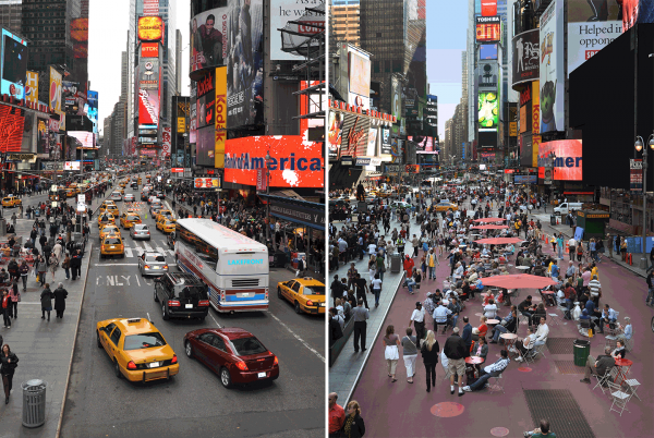
Figure 2:
Times Square Pedestrian Plaza
Source: Sadik-Khan, 2016
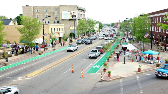
Figure 3:
Tactical Cycle Track & Plaza, OH
Source: Better Block, 2019

Figure 4:
Seattle Design Festival Play Street
Source: ArchitectureGeek, 2019
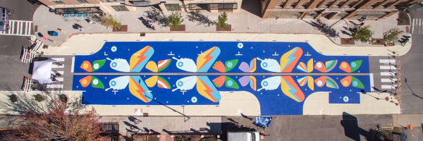
Figure 5:
Coxe Street Mural, Asheville
Source: Street Plans, 2019
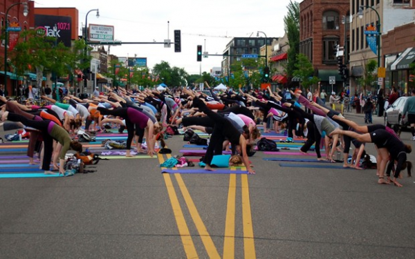
Figure 6: Street Yoga Source: Street Plans, 2019
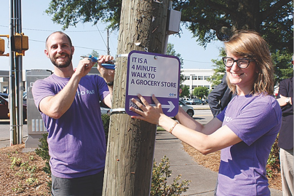
Figure 7: Wayfinding Signs, NC Source: Walk Raleigh, 2018
2.3.4. Benefits of Tactical Urbanism
Case studies of tactical urbanism are increasingly well documented and it is widely acknowledged that the benefits of this approach are multi-faceted. These benefits distil to four key areas:
- Responsiveness
Pfieffer (2013) argues that unlike strategic planning approaches with long-term implementation horizons, tactical urbanism is more responsive to changing social, physical and economic conditions. The ‘quick, cheap and light’ nature of the approach enables cities to pursue long-term goals, while embedding agility into the physical environment and adaptability in the delivery process. By accommodating iterative changes, these interventions demonstrate a willingness to test ideas empirically and respond to feedback from users. Co- founder of the Congress for New Urbanism, Anders Duany claims that this is “important for shifting planning practice to one that is more frugal and adaptable”. Indeed, tactical urbanism aligns urban democratic instruments with the digital age and cultural expectations for instantaneous responses from government to citizenry (Lyndon & Garcia, 2011).
- Community Engagement
Tactical interventions are invariably strong tools for community engagement; taking abstract planning concepts and turning them to tactile installations for citizens to experience. This circumvents contentious debate based on hypotheticals and enables people to easily, tangibly and constructively engage in the city building process (Lyndon & Garcia, 2011). Rieniets (2009) claims that this is important amidst a push to “rethink the legal, institutional and political frame of urban planning to make way for more transparent and inclusive planning processes”. Indeed, more recent evidence [Bishop & Williams, 2012], shows that “while people are turning away from formal political involvement...people remain willing to engage in issues that are perceived to concern them directly, and are no longer willing to be the passive recipients of government services or decision making” (p. 138).
- Politics
Politically, tactical urbanism is an expedient tool for overcoming the contentious socio-cultural barriers that exist when planning shared public spaces. In her book ‘Street Fight’ documenting New York’s journey with tactical urbanism, Sadik-Khan (2016) found that it’s low-cost, iterative and reversible nature neutralised the ardent defenders of the status quo, or ‘NIMBYs’, enabling grass-roots support for change to grow. With this social and political capital, support can then be leveraged for larger, long-term change (Lyndon & Garcia, 2011, p. 14).
- Resources
The global appeal of tactical urbanism is largely attributable to its physical and financial resource efficiency. Pfieffer (2013) and Davidson (2013) highlight that the cost of making conventional urban improvements can be prohibitive, with a lack of resources allocated for this task in municipal budgets. Sadik-Khan (2016) claims this ability to use cheap materials such as paint, planter boxes and chairs lowers the risks and costs for both officials and citizens, freeing tacticians to publically experiment with bold and innovative ideas for urban improvement.
- Caveat
Notwithstanding these benefits, researchers [Lyndon & Garcia, 2011; NZ Transport Agency, 2019; Davidson, 2013] widely agree that tactical urbanism alone is not a panacea for our urban problems or government dysfunction. While the interventions carry an intrinsic value, they should not render formal planning processes or capital-intensive infrastructure projects obsolete. Instead, tactical urbanism should be treated as a provisional catalyst for these more permanent ends, an incremental approach to planning. As surmised by architect Nabeel Hamdi, tactical urbanism should simply disturb the order of things in the interests of change.
2.3.5. Tactical Urbanism and Planning
It seems counter-intuitive that an approach aiming to bypass the requirements of the planning system could be entertained as a tool within mainstream planning. Indeed, Pfieffer (2013) acknowledges that the role of professional planners and the potentially unsanctioned acts of tactical initiatives appear to be at odds with one another. Notwithstanding this paradox, cities are increasingly integrating tactical urbanism into their planning processes as city officials recognise its capacity to respond to the dynamic needs of citizenry (Gerend 2007, Greco, 2012). Despite the growing momentum in practice, few researchers have addressed the issue of tactical urbanism’s formal role within planning. Pfeiffer used this literary void as justification for developing the ‘Planner’s Guide to Tactical Urbanism’.
Traditionally, planners have been professionally bound to regulatory frameworks and the creation of strategic documents which guide long-term, capital intensive urban development. However, Arlt (in Hayden and Temel 2006) contend that this top-down, strategic planning which relies on both power and money is no longer possible. Instead, proposing that decentralised, collaborative methods to engage diverse stakeholders in decision making will become the dominant planning praxis (ibid. P 16). This is supported by Lang Ho (2012) who sees a new balance emerging in the planning discipline, noting that “these micro urban movements - vast in number, ephemeral, situational, intelligent, idiosyncratic - can’t replace the effectiveness and reach of top down planning. But somewhere in between the two seem to be finding common ground” (p.3).
There is a clear theoretical tension between tactics and strategies. de Certeau (1984) claim that tactics are historically associated with the subversive actions taken by the weak or the marginalised in warfare. Strategies, by contrast, were a tool of the powerful. However, Lyndon & Garcia (2011) contest this definition, observing that we are increasingly seeing that tactical interventions are not always subversive or unsanctioned and are not only employed by the weak or marginalised. Tactics can instead be defined as “an activity concerned with individual acts [or engagements]... while strategy, by contrast, is concerned with the use and significance of the totality of engagements” (Blau, 2011, p. 61). This definition implies that tactics and strategies can co-exist, with larger strategic planning generating opportunities within which more immediate tactical planning can function.
Following the conclusions of Blau (2011) and Klayko (2012), this dissertation accepts that tactical urbanism is not at odds with planning, but instead is just another tool that planners can use to develop or fulfil longer-term plans and strategies, like active transport promotion.
2.3.6. Supporting Tactical Urbanism in Planning
Though many tactical interventions seek to bypass bureaucracy and formal planning processes, eventually they must come back to government for support to formalise their success and achieve genuine long-term change. Lyndon & Garcia (2011) contend that:
“although these initiatives often begin with smaller citizen advocacy efforts, the benefits of tactical urbanism become clearer as they are integrated into the municipal project delivery process and capably brought to neighbourhoods across the city” (ibid, p. 8).
Multiple researchers (Davidson, 2013; Lydon and Garcia, 2011; Pfeiffer, 2013) agree, therefore, over the increasing importance of institutional and regulatory frameworks that accommodate tactical urbanism. However, the characteristics of these supportive frameworks are under-researched, with international best practice largely informed by successful case studies.
2.4. Tactical Urbanism & Active Transport
This literature review demonstrates clear synergies between the challenges for walking and cycling infrastructure provision and the ability of tactical urbanism to overcome conventional planning barriers. The ‘quick, cheap and light’ nature of tactical urbanism avoids mega-project monomania, enabling small local improvements to streets and crossings within high-level strategies for active transport promotion (Lyndon & Garcia, 2011; Sadik-Khan, 2016; Aline & Adriana, 2017).
As an emerging tool, what is known about the interface between tactical interventions and active transport infrastructure is modest and largely based on examples of international practice. The design, materials and interventions used to pursue these infrastructural improvements can vary significantly between contexts as exemplified by Figures 8 – 13.
Although large transformative projects do still have their place, planning practitioners argue that they alone are rarely enough to secure the necessary buy-in for a modal shift away from cars. Lydon & Garcia (2011) suggest that cities must employ small tactics to retrofit streets and engage citizenry, thereby stimulating grass-roots change. This dissertation will add to the emerging body of literature in this area, by investigating how Auckland’s planning framework can unlock the full potential of these tactical approaches for the promotion of active transport.

Figure 8:
Tactical Improvements, Inglés, Bogotá
Source: Plazoletas Bogota, 2019
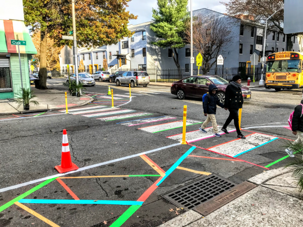
Figure 9:
Crossing Facilities, New Jersey
Source: Street Plans, 2018
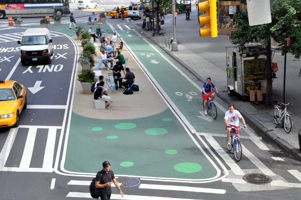
Figure 10:
Tactical Cycle Lane, Broadway, NYC
Source: People for Bikes, 2014
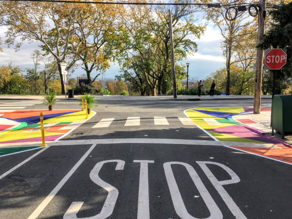
Figure 11:
Crossing Improvements, New Jersey
Source: Street Plans, 2018
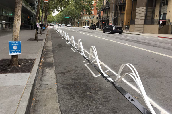
Figure 12:
Wave Cycle Lane Delineators, CA
Source: Saris Infrastructure, 2018
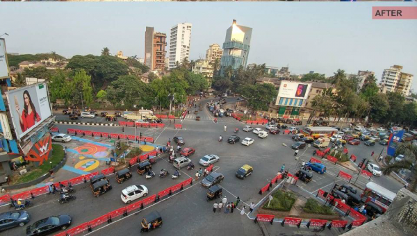
Figure 13:
Intersection Improvement Bollards, Mumbai
Source: Hindustan Times, 2017
3.0. Methodology
3.1. Research Design
To address the research question, a two-phase research strategy was developed combining qualitative techniques common to urban research. The first phase comprised a desktop evaluation of Auckland’s existing transport planning framework, including strategic documents, regulations and institutional structures (Chapter 4). This evaluation sought to identify barriers within Auckland’s planning framework that reduce tactical urbanism’s viability within transport planning. The second phase presents four case studies to demonstrate the impacts of varying planning frameworks on the success of tactical urbanism in improving walking and cycling infrastructure (Chapter 5). These two phases, data collection processes and the limitations of this research are detailed briefly below.
3.2. Council Reports & Information Acquisition
Recognising that tactical urbanism is a new approach in Auckland, limited information was available in the public realm through the traditional information channels. To fill this void, secondary data was obtained from the Auckland Council, Auckland Design Office and Auckland Transport under the Local Government Official Information and Meetings Act (1987). Formal submissions were made to these public authorities, requesting all documents, reports (both internal and external), advice to officials and memorandums relevant to the requests. The details of these submissions are attached as Appendix 1 and 2.
3.3 Framework Evaluation
An evaluation was undertaken of relevant areas within Auckland’s transport planning framework to identify current strategies, regulations, processes and institutional structures which support, or hinder tactical urbanism. Although tactical urbanism is seldom referred to directly in these documents, elements of interest were those that restrict the approach’s use – such as traffic control device regulations.
3.4 Case Study Selection Criteria
In this phase, an initial search was conducted for tactical and ‘quick-build’ projects that had been implemented or planned in Auckland. The focus of this search was identifying interventions that were intended to be short-term, comparatively low-cost and make an improvement to the conditions for pedestrians or cyclists within the road reserve. This research was supported by the official information supplied under the LGOIMA.
This same criterion was then transferred to a search for comparable tactical interventions across North America, Australia and Europe. Of interest were successful projects that had been developed within the city’s official planning framework and in which planners or officials had been directly involved. Projects were only included if there was sufficient literature outlining the official planning processes for these interventions.
Following this search, two Auckland case studies and two international case studies were selected for analysis in Chapter 5. Given the intra-approach variety of tactical urbanism, the selection of just one international and one local case study would have provided insufficient grounds for comparison. The analysis of two Auckland case studies highlighted common barriers to tactical urbanism’s use as a transport planning tool within the existing framework. Conversely, the analysis of Burlington and San Francisco illustrated the potential for walking and cycling infrastructure when tactical urbanism is unlocked by supportive planning frameworks.
It is important to highlight that tactical urbanism interventions are heavily inspired by and responsive to the local urban conditions in which they are undertaken. In addition, planning frameworks and their support of tactical urbanism vary significantly between municipal authorities. So too do the existing standards of walking and cycling infrastructure, as well as the other factors that influence a population’s modal preferences. For these reasons, it is challenging to draw direct comparisons between interventions.
3.5 Limitations
It is important to note that there are several limitations to this research. Due to the limited time frame and scope of the dissertation, it was not possible to be exhaustive in the search for tactical projects and supportive frameworks in international cities. Therefore, the case studies chosen in Chapter 5 are merely a sample, intended to showcase the diverse outcomes, planning frameworks and official responses to tactical urbanism for walking and cycling infrastructure.
In addition, it has proved challenging to research such a dynamic area of the global planning discourse. With recently amplified concerns for transport-related emissions and a growing awareness of tactical urbanism, there is a constant flow of new resources. To the extent possible, all new articles, guides, government reports, policy documents, books, and project advancements were incorporated into this research.
4 Framework Evaluation
4.1. Strategy Overview
4.1.1. Auckland Regional Land Transport Plan (2018 – 2028)
The Regional Land Transport Plan (RLTP) is the preeminent statutory document outlining the strategic direction for Auckland’s transport network under the Land Transport Management Act (2003) and Government Policy Statement on Land Transport (2019). A joint initiative between Auckland Transport, NZTA and the Ministry of Transport, the RLTP identifies objectives, priorities and measures for the coming decade, guiding the city’s transport network development and investment.
One of the top priorities in the RLTP is to “encourage the move away from single-occupant vehicles as the dominant mode of travel, enabling public transport, walking and cycling to play a significant role in the transport system” (p. 37). This priority is underpinned by the need to better accommodate growth, reduce congestion, improve the city’s natural environment and respond to the urgency of climate change. To give effect to this priority, the plan aims to facilitate “an increase cycling modal share, create streets that support pedestrian and cyclist priority and develop safer, better connected and more attractive walking and cycling infrastructure” (p. 37). Simultaneously, the RLTP acknowledges the challenge of increasing “time, cost and complexity to the planning, funding and delivery of conventional transport projects and services” (p. 28). Ultimately, this strategic intent aligns with cities globally in being supportive of active transport infrastructure improvements and cost-effective planning techniques.
4.1.2. Auckland Transport Design Manual & Urban Streets and Roads Design Guide (2019)
The Auckland Transport Design Manual (Manual) is a series of non-statutory documents released by AT progressively since 2017. The Manual comprises a cascading strategic framework including guides, engineering design codes and specifications which collectively govern the planning, design, management and construction of Auckland’s transport infrastructure (Auckland Transport, 2018).
A central feature of the Manual is the ‘Roads and Streets Framework’ (refer to Figure 14) that revolutionises the road classification system to better account for the diversity of strategic functions fulfilled by Auckland’s streets. By moving away from the car-centric grading metric of traffic flow, this new approach aims to improve the strategic planning for each street, having regard for a variety of modal priorities, speeds and street design.
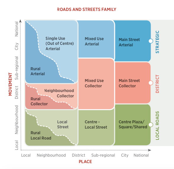
Figure 14: Auckland Roads and Streets Framework
Source: Auckland Transport, Urban Streets and Roads Design Guide (2019, p.8)
Another key layer of this Manual is The Urban Streets and Roads Design Guide (USRDG), released in September 2019. This document sets out guiding principles for the design and integration of activities within Auckland’s street, based on international best practice. It prescribes that the city’s design and planning must “support safe, comfortable and attractive multi-modal transport for all users…[and]… as Auckland changes and adopts different priorities, the street designs should reflect these new conditions and priorities”. To achieve these directives, AT sets out guidance for street design that incorporates walking and cycling infrastructure improvements. Importantly, the guide also encourages “quick, low-cost interventions that can serve as interim stages to more long-term visions” (p. 31). Within the USRDG the example is given of psychological features using colourful materials to create visual narrowing’s and reduce vehicle speeds (p. 115). However, these design suggestions are made despite being in contravention of the Traffic Control Devices Manual and requiring approval for use by NZTA (refer to Section 4.2.1.).
4.1.3. Strategy Summary
Ultimately, this overview demonstrates that at a strategic level, both AT and NZTA are looking to promote active transport and bolster the safety of pedestrians and cyclists in Auckland. Across these documents, improved walking and cycling infrastructure is identified as central to achieving this, with attempts to embed the concerns of vulnerable road users into the fundamentals of planning and street design. Notwithstanding this intent, neither organisation sets out a road map for the delivery of this significant step-change at the lower planning levels. For example, while there is some mention of tactical urbanism as a tool for delivering new traffic control devices, there is a lack of detailed support for delivery on-the-ground.
4.2. Regulations
4.2.1. Traffic Control Devices Manual & Land Transport Rule: Traffic Control Devices (NZTA)
The Land Transport Rule: Traffic Devices (2004) establishes requirements for the “design, construction, installation, operation and maintenance of traffic control devices, and sets out the functions and responsibilities of Road Controlling Authorities (RCAs) in providing traffic control devices to give effect to their decisions on the control of traffic”. Within the Rule, a traffic control device (TCD) is defined as “a device used on a road for the purpose of traffic control, including signs, signals, traffic calming devices, markings and road surface treatments”. As identified in Chapter 2, these devices are fundamental elements of improved walking and cycling infrastructure and tactical street design.
As an RCA, the Rule authorises Auckland Transport to install, operate or remove traffic control devices if it is deemed to be desirable for the guidance of traffic, or to draw attention to a hazard. However, Section 3.3 restricts the inventory of devices to those set out within the Rule’s schedule. The Traffic Control Devices Manual (TCDM) accompanying the Rule aims to provide interpretive clarity on the legislative requirements for these devices, contextualised with international best practice for TCD application. For example, under the TCDM, the use of coloured surfacing for cycle lanes is restricted to situations outlined within the technical design notes and must use only the “AS 2700 S 1996 Colour G13 Emerald” colour. These prescriptive, detailed specifications align with the Rule’s primary objective set out in Section 1.3:
“to contribute to a safe and efficient roading environment for all road users by ensuring that traffic is controlled by devices that are safe, appropriate, effective, uniform and consistently applied” (sec 1.3).
As demonstrated above, there is a sustained emphasis on the importance of consistency and uniformity within the road reserve throughout the Rule and TCDM. This emphasis seeks to ensure that the form, appearance and placement of devices create ‘no surprises’ street environments, with standardised traffic control treatments that can be easily understood by drivers across NZ. However, it appears that in the Rule’s enforcement, the term consistency has become synonymous with a lack of innovation, instead favouring the predictability of known devices more than potentiality of new innovations, particularly those for multi-modal safety. This can be problematic for RCAs wanting to adopt more versatile and responsive tactical street treatments (that fall outside of the TCDM) into their mainstream transport planning. Indeed, through the Rule, NZTA bind RCAs to business-as-usual planning practices, which have historically favoured the private car over active modes (Faherty & Morrissey, 2014). This heavily restricts the ability of RCAs like Auckland Transport to respond flexibly to context- specific demands for innovative walking and cycling infrastructure improvements.
- TCDM Amendments & New Devices
Clause 3.4 of the TCD Rule sets out that any new devices or departures from the TCDM such as tactical polka-dot road markings, require a robust and resource-intensive NZTA approval process. The requirements of this process are prescribed within NZTA’s Traffic Note 10, beginning with a detailed application to the Traffic Control Devices Steering Group (TCDSG). This group meets just once every three months to review a trial proposal, providing advice to NZTA on an application’s merits, assuming that it would result in the non-conforming TCD being included within nation-wide policy. Importantly, under the Land Transport Act (2004), all roads are viewed the same and thus, trials for any new devices are mandatory – whether the proposed site is a 100km/hr state highway, or a 15km/hr laneway. For the NZTA to justify the trialling of a new device, there is an expectation that it has viable applicability across all roads irrespective of their risk-level, speed, modal priorities or RCA strategy. There is currently no exemption within the Rule for tactical interventions on low-risk, low-speed street environments. This appears to present a disconnect with the Auckland Transport Urban Streets and Roads Framework, which recognises the value of innovation and varied functions of urban streets (refer to Section 4.1.2).
If approved, NZTA and the RCA are required to conduct the trial under TCDSG conditions in order to ascertain an exhaustive understanding of the device’s costs, benefits, safety effects, resource consumption, implications for road users and the extent to which it solves a problem. If the subsequent trial is deemed to be successful, the TCD Rule is then amended to enable all RCAs to adopt this device. Notwithstanding the importance of the scientific method for ensuring safety, this trial process for new devices is extensive, capital-intensive and can take up to three years for conclusive results. These implications of the Clause 3.4 trials contravene the nature of ‘quick, cheap and light’ tactical interventions.
- Road Controlling Authorities & Unsanctioned Projects
Additionally, in assigning authority to RCAs such as AT, Section 3.2(2) of the Rule prohibits the modification of road reserves by ‘unsanctioned’ community actors, stating that “a person must not provide or operate a traffic control device on a road without first obtaining approval from the road controlling authority in control of that road”. This largely restricts the tacticians within Auckland’s urban streets to those familiar with the formal AT approval processes. Those approval processes are required to have regard for the policies and rules established by NZTA, rendering NZTA an indirect, but key gatekeeper for all active transport related tactical projects.
4.2.2. Code of Practice for Temporary Traffic Management
The Code of Practice for Temporary Traffic Management (COPTTM) is an extensive code constituting Part 8 of the TCDM. Although not a statutory document, CoPTTM has been developed to assist practitioners in meeting the legislative requirements of the TCD Rule, Land Transport Act (2004) and Health and Safety at Work Act (2015). It describes “best practice for the safe and efficient management and operation of temporary traffic management on all roads in New Zealand” (p. iv). The code applies to “any activity that varies the normal conditions of any road and applies to the total road reserve “(p. iv). Thus, CoPTTM affects the implementation or construction phase of any tactical transport projects on New Zealand’s streets.
- Traffic Management Plans
One of the key principles of CoPPTM set out in Section A1 is that “all on-road activities must be carried out in accordance with a Traffic Management Plan (TMP) that has been approved by the RCA or delegated person”. TMPs are described in Section A7 of CoPTTM as site- specific plans that must outline the design, implementation, management and removal of temporary traffic measures while an activity is carried out in the road corridor. These plans aim to identify and minimise any potential inconvenience to road users and health and safety risks to road users and contractors conducting works.
Although TMPs are commensurate with the size and scale of works being undertaken, the minimum requirements are comprehensive and can only be submitted to the RCA by an NZTA qualified ‘Site Traffic Management Supervisor’ (STMS). This prerequisite increases the specialisation required for tacticians seeking to implement tactical interventions, or, in most cases requires the engagement of consultants. This increases both the expense and timeline of the requirements, to a level that would be expected of conventional, permanent, capital- intensive infrastructure projects. It also decreases the responsiveness of tactical interventions, by complicating the process for making iterative changes on the ground. Ultimately, these TMP barriers undermine the feasibility of tactical interventions that are otherwise intended to be cheap, fast and responsive.
4.2.3. Regulations Summary
In their current form, NZTA’s TCDM, Land Transport Rule and CoPTTM appear to present significant regulatory barriers to the implementation of tactical improvements to the road reserve. The prescriptive and inflexible rules governing TCDs outlined above appear to enforce the obduracy of existing solutions to Auckland’s transport planning issues and perpetuate a tradition of extended process timeframes and capital-intensive infrastructure delivery. Thus, entrenching a resistance to tactical urbanism for the benefit of active transport promotion.
Despite an expressed strategic will to accommodate people-centric streets and innovation as noted in Section 4.1, these regulations compel path dependency and a high level of uniformity that engenders business-as-usual behaviour. As aptly noted in the common adage, ‘if you always do what you have always done, you’ll always get what you have always got’. In the case of these regulations, this is a transport planning practice that prioritises private vehicles and traffic flow over the increasing demands of pedestrians and cyclists.
In September 2019, the NZTA released its first resource which seeks to inform and guide the implementation of new tactical urbanism interventions on New Zealand streets. Entitled ‘Innovating Streets for People’, the guide provides a local adaptation of international best practice guides for tactical interventions with step-by-step instructions for negotiating the complexities. While the guide is successful in demystifying some of the key legislative and regulatory requirements impacting tactical urbanism, it does not remove these fundamental barriers. In reality, for tactical urbanism to be a successful in transport planning, the agency needs to emancipate it from the restrictions of archaic legislation1. While this analysis has identified regulatory barriers, the question remains about how insurmountable these barriers are – if at all. Two local case studies will subsequently be analysed in Chapter 5 to address these questions and implications for practice.
1 When the Land Transport (Road User) Rule was enacted in 2004, the urban policy agenda strongly prioritised private vehicles and traffic flow on New Zealand’s roads.
4.3. Institutional Structure
4.3.1. Context
As aforementioned in Section 4.2.1, unsanctioned acts on the road reserve are prohibited under the Land Transport Rule: Traffic Control Devices (2004). Consequently, official institutions are central to the planning and implementation of any street-related tactical interventions. As an RCA and with delegated responsibility for Auckland’s active transport network, AT is a particularly important actor. For tactical urbanism projects in the CBD, AT are supported by Auckland Council’s specialist urban design unit the Auckland Design Office (ADO).
4.3.2. Auckland Transport: Walking and Cycling
Prior to 2018, a dedicated walking and cycling unit within AT had responsibility for active transport promotion, the delivery of walking and cycling infrastructure and collaboration with the ADO on street-related tactical interventions. This unit was behind Auckland’s largest ever cycling infrastructure investment, as well as several innovative tactical projects including the Federal Street Contra-Flow Cycleway. However, in November 2018, AT CEO Shane Ellison announced a significant restructure which saw the walking and cycling team disbanded in favour of an “organisation-wide focus on walking and cycling and the outsourcing of urban design functions to the ADO and specialist consultants” (Gracewood, 2018). The decision was widely criticised for its failure to recognise the importance of remedying significant under- investment in active transport modes, as well as generating a diffusion of intra-organisation responsibility for active transport promotion (Gracewood, 2018). This aligns with the assessment of Rieniets (2009), that the current institutional and planning tools have “become fragmented and opaque in the throes of history” (p. 22).
Under the new structure, there is no single team driving growth in the organisation’s capacity to roll out more cycling and walking friendly streets. For example, the unit is not available for training, specialist expertise or internal consultation on either active transport or tactical urbanism projects. This is particularly pertinent for AT’s engineers and planners who will be using the new standards under the USRDG, many of whom have previously worked under regimes that have overseen significant underinvestment in and marginalisation of active modes. Banister recognises this as a common barrier to walking and cycling infrastructure, noting that “an unstable administrative organisation and unqualified personnel may reduce the capacity to implement” (Rietveld & Stough, 2005; p.55).
Beyond that, there is also no team driving familiarity with, and proliferation of new, innovative planning tools like tactical urbanism. This includes no single point of contact for AT’s collaboration with the ADO, other CCOs and key stakeholders to ensure that active modes are prioritised and well accounted for in tactical projects. The unit’s dissolution means that expertise necessary to negotiate the regulatory complexities of tactical transport projects is dispersed, causing a loss of momentum for challenging work. For example, tactical projects such as the Sales Street intersection reconfiguration have not been able to circumvent the requirements for TMPS or Safety Audits, as they could when the walking and cycling unit were advocates internally; increasing the cost and project timeline for the ADO. This current state emulates that of the Auckland governance structure prior to amalgamation, characterised by inter-governmental antagonism, fundamentally hindering active transport promotion efforts (Faherty & Morrisey, 2014)
4.3.3. Tactical Program: Auckland Design Office
The ADO is Auckland Council’s specialist urban design team composed of experts in tactical urbanism who are charged with overseeing the city’s tactical program including place-making initiatives and infrastructural improvements. While a valuable resource, this department is funded by the city-centre targeted rate and, therefore, their work is restricted geographically to just that within the CBD. This creates imbalances within the city, in that metropolitan centres outside the CBD do not have the specialist resources to deliver tactical projects, despite having equally dangerous street environments.
4.3.4. Summarised Findings
This ultimately demonstrates that the current organisational structure erects a number of institutional barriers to the progress of tactical urbanism for walking and cycling infrastructure improvement. Particularly when compounded with the regulatory barriers identified in Section 4.2.
It is important to note that this evaluation has pertained solely to the structure of organisations and has not considered the internal cultures of AT or the ADO.
5.0. Case Studies
5.1. Auckland Case Studies
5.1.1. Tactical Crossing – Newmarket Station Exit, Auckland
5.1.1.1. Context
Newmarket is a key metropolitan centre located approximately three kilometres south of Auckland’s central business district. The centre contains a diverse mix of uses including retail, commercial and residential as well as a key arterial road, generating a complex urban environment with competing modal priorities. In June of 2019, Auckland Transport commissioned a private consultancy with the investigation of operational improvements to the Newmarket Metropolitan Centre. This investigation sought to identify a number of improvement work streams, with implementation periods ranging from three months to 1-3 years. In particular, the investigation aimed to address multi-modal deficiencies on the road network, with a focus on increasing pedestrian connectivity, safety and wayfinding between key land use activities.
The urgency of this investigation was due to the imminent completion of the Westfield Shopping Centre extension, expected to generate an additional 32,000 visitors per day, rising to 60,000 for event days. AT expected that this additional travel demand would place pressure on the pedestrian network, threaten Newmarket’s user experience and discourage active transport.
5.1.1.2. Site
An un-signalised pedestrian crossing at the intersection of Broadway and Teed Street was identified in the investigation as a priority site requiring immediate improvements. This crossing serves a dominant pedestrian desire line, between the Newmarket Railway Station egress and the opposite side of Broadway (adjacent to Teed Street). The double-refuge is frequented by pedestrians accessing Teed Street, the Westfield Shopping Centre, high frequency bus stops, local schools, offices, eateries and boutique retail destinations north- west of the exit (refer to Figure 15). However, these pedestrians are subject to significant safety risks due to poor crossing facilities, a wide carriageway, pedestrians crossing through queuing traffic, high vehicle speeds and pedestrian inattention. Indeed, the crossing provides no prioritisation or delineation on the 23m wide carriageway to protect pedestrians from the four live traffic lanes (refer to Figures 16 & 17). Currently if pedestrians wish to cross at a signalised crossing for this desire line, the nearest on Broadway is either 50m south of the exit, or 90m north of the refuge.
Figure 15: Newmarket Station Exit, Broadway & Teed Pedestrian Desire Lines

Source: Newmarket Aerial [Map]; Google Maps (2019). Annotations made by Declan Weir (2019)
Observations noted that vehicles infrequently stopped to let pedestrians cross and many waited on the unprotected refuge for long periods of time. In the last five years, 16 of 29 (55%) crashes in the Newmarket Metropolitan Centre occurred along Broadway (NZ Transport Agency, 2019). 44% of these accidents involved pedestrians crossing through queued traffic. The Teed Street/Broadway intersection is historically a particularly high risk area, with four crashes involving pedestrians at this location.
Figure 16 & 17: Existing Pedestrian Refuge – Broadway/Teed Street Intersection
Source: Teed Street/Broadway Pedestrian Crossing [Photograph]; Weir, D (2019).
5.1.1.3. Tactical Intervention
The subsequent options report to AT recommended the immediate installation of a tactical, low cost ($25,000) and non-conventional traffic calming intervention. It was expected that this would improve the crossing facility and bolster pedestrian safety temporarily, while AT consolidated the funds and developed a scheme for a formal, signalised crossing.
The proposal involved the installation of red polka-dot road markings on the carriageway, for perceptual friction, drawing driver attention to the presence of pedestrians and communicating the need for increased caution. This recommendation was accepted by AT and proceeded to the concept design stage (refer to Figure 18). This aligned with the purpose of the investigation and the USRDG’s recommendation of innovative psychological traffic calming techniques (Auckland Transport, 2019). Similar tactical polka dot markings have previously been shown to result in a 5.4% slowing of the 85th percentile speed from 33.2km/hr to 31.4km/hr - improving pedestrian safety (Auckland Transport, 2019).
Figure 18: Concept Design for Tactical Station Exit Crossing
Source: Newmarket Operating Plan Concept Design, Auckland Transport (2019). Obtained through a request under the LGOIMA.
5.1.1.4. Outcome
Despite political will, pressure to make immediate improvements to the pedestrian environment and the high priority of this site, the tactical crossing was dismissed from the work stream in August 2019. AT instead chose to implement a permanent, signalised crossing predicted to take upwards of 12 months to construct with an estimated order cost of $200,000
- eight times the cost of the proposed tactical intervention (refer Figure 19).
Figure 19: Concept Design for a Signalised Pedestrian Crossing
Source: Newmarket Operating Plan Concept Design, Auckland Transport (2019). Obtained through a request under the LGOIMA.
A number of reasons were cited for the abandonment of the tactical crossing. However, the most consequential factor was the onerous requirements of the TCD trial and approval process, which would have extended the project timeline from a three-month implementation window, to upwards of two years. Additionally, the costs associated with these trials, monitoring and reporting threatened to inflate the project delivery costs significantly beyond the $25,000 estimate, absorbing a significant fraction of the overall budget for Newmarket improvements.
Collectively, these barriers undermined the original intent of developing a ‘quick, cheap and temporary’ solution to improve the pedestrian facilities, creating a vacuum of uncertainty around feasibility. This uncertainty rendered the prospect of a permanent, signalised crossing with known time frames and costs a more feasible option for AT’s engineers.
5.1.1.5. Summarised Findings
This case study demonstrates that despite high priority status, immediate need for pedestrian improvements and a low budget, several conflating regulatory and institutional barriers currently render tactical crossing facilities untenable.
5.1.2 Federal Street Contraflow Cycleway
5.1.2.1. Context
Federal Street is a one-way street within the Auckland CBD that forms a key segment of the city’s ‘Laneway Circuit’. In July 2016, AT and the ADO commenced planning to transform the car-dominated street, between Victoria Street and Fanshawe Street, with a trial of Auckland’s first contra-flow cycle lane. Contra-flow cycle lanes are a globally popular cycling infrastructure treatment, that “encourage more people to cycle, as they allow cyclists to use safe and direct routes, avoiding unnecessary detours. Contraflow cycle streets have been proven to be safer than other one-way streets” (Global Designing Cities Initiative & NACTO, 2016, p. 101). The contraflow cycle lane trial leveraged heavily off the closure of parallel Albert Street due to City Rail Link construction, with Federal Street identified as an important north-south alternative for cyclists.
5.1.2.2. Tactical Intervention
The trial improvements on Federal Street used colourful, low-cost materials to implement the painted bicycle lanes, physical buffering, intersection modifications and traffic calming measures (refer to Figure 21). The centrepiece of this project was the protected southbound contra-flow cycle on Federal Street’s eastern side, consisting of green road markings, flanked by a physical buffer of coloured place-kit planter boxes and armadillos. This was complemented by painted kerb build-outs, painted crossings and colourful polka-dots intended to calm traffic and improve the safety conditions for both pedestrians and cyclists (refer to Figure 20).
Considering the trial nature of this project, utilising tactical urbanism enabled the new road layout changes to be iterative, testing and altering the new treatments to ascertain optimal performance before proceeding with the permanent Federal Street Upgrade. As noted in Chapter 2, this approach also empowered the community to experience the innovative cycleway empirically, providing feedback to AT accordingly.
Figure 20: AT Scheme Plan for the Federal Street Tactical Interventions
Source: Federal Street Contraflow Cycleway Scheme Plan, Auckland Transport (2018). Obtained through a request under the LGOIMA.
5.1.2.3. Outcome
Following a 21-month planning process, the project was delivered in March 2018, with a total cost exceeding $100,000. Overall, an 82% rise in cyclists was recorded on Federal Street, with pedestrian volumes doubling and traffic calming measures reducing average vehicle speeds from 27.7km/h to 22.2 km/h (refer to Appendix 2). The trial infrastructure also successfully transitioned Federal Street’s modal priority away from the private car, with traffic volumes decreasing between 44-75% across the street’s monitoring locations. An evaluation of the trial noted that “the contra-flow cycleway and temporary street improvements on Federal Street have improved connections through the city centre… [and] demonstrated the effectiveness of this intervention for improving the amenities and routes for people who cycle” (Mackie Research, 2018, p. ii).
Despite the project’s successes for active transport, AT and the ADO experienced numerous challenges in the tactical delivery, resulting in an extended project timeline. Chiefly, the planners found a lack of institutional urgency, due to the Council and CCOs within the Council accustomed to long sign-off processes and high quality finishes of permanent projects (Buckle & Davis, 2019). The requirement for TMPs was also a cause of cost and delay, with contractors required to fulfil the CoPTTM requirements, adding to the complexity of the delivery process that is intended to be quicker, lighter and cheaper (Buckle & Davis, 2019).
Figure 21: Federal Street Tactical Improvements
Source: Auckland Transport, 2019
5.2.1.4. Summarised Findings
This case study enforces the value of tactical urbanism as a tool for delivering more people- centric streets, with the Federal Street treatments directly enhancing network connectivity and increasing the active transport modal splits. It also demonstrated the value of tactical urbanism as a tool for community engagement on innovative new infrastructure – consultation by trial.
Notwithstanding these benefits, the project’s extended delivery timeframe and significant cost expose the regulatory, resource and institutional barriers for Auckland’s active transport tacticians, that can undermine the ‘quick, cheap and light’ nature of the approach.
5.2 International Case Studies
Considering the barriers for tactical transport projects identified within the Auckland planning framework, enforced by the local case studies above, two exemplar international case studies are outlined below. These demonstrate the propensity of tactical urbanism to deliver strong outcomes for active transport, when emancipated by the appropriate regulatory and institutional support. Burlington’s is a framework that focuses on council-led quick-build projects; while San Francisco’s, focuses on citizen-led tactical interventions.
5.2.1 Quick Build Program: Burlington, Vermont
5.2.1.1. Context
Burlington, Vermont is a small city of 42,000 people located on the East Coast of the United States of America (U.S.A.), that has recently ascended as a leader in the ‘quick-building’ of walking and cycling infrastructure. In 2017, the city’s Department of Public Works launched their ‘quick-build system’ to deliver “a phased approach to bicycle and pedestrian infrastructure projects that improve safety and connectivity” (City of Burlington, 2018). This programme comprises three tranches, including: ‘Plan BTV Walk Bike’; the Quick Build Project Materials & Design Guide; and city ordinance amendments. Each of these aims to fulfil the city’s ambitious vision of becoming “the best small city for walking and biking on the east coast”.
5.2.1.2. Programme
Plan BTV Walk Bike
‘Plan BTV Walk Bike’ is the quick build programme’s guiding document. It was developed in 2017, in response to extensive public consultation, which revealed that the primary deterrent to walking and cycling in Burlington, was poor infrastructure and safety concerns (refer to Figure 22). The comprehensive plan ultimately aims to address these by improving the conditions for pedestrians and cyclists, and in turn, increasing the active transport mode share.
The Plan sets out a road map for the transformation of the city’s highest risk streets, to ensure that physical design enforces slower, more careful driving and modal separation. For each street classified as ‘high-risk’, the plan sets out a 12-Month Action-Plan, with a number of quick-build improvements that can be implemented using low-cost materials. These action plans are intended to allow community members to experience and evaluate low-cost, quick- build improvements before committing to long-term capital upgrades. Thus, acting as stepping stones for the Plan’s 2-5-year projects.
Figure 22: BTV Public Consultation Data – Walking & Cycling Deterrents
Source: Plan BTV Walk Bike
Quick Build Project Materials & Design Guide
To support engineers and planners in delivering the 12-month action plans, the ‘Quick Build Project Materials & Design Guide’ was established. This guide is broken into two sections. Firstly, the Design Standards provide advice on the application, design components, dimensions, and implementation of various quick-build street treatments such as tactical cycle lanes and kerb extensions (refer to Figures 23 & 24). Secondly, the Materials Standards set out a “detailed palette of barrier elements as well as surface materials that are appropriate for quick-build projects”. Therefore, this guide streamlines the implementation process by ensuring that from the outset, designs follow the requirements of the public works department and are consistent with local traffic control device regulations.
Figure 23: Quick-Build Cycle Lane Design Guidance, Burlington
Source: Quick Build Project Materials & Design Guide
Figure 24: Quick-Build Curb Extension Design Guidance, Burlington
Source: Quick Build Project Materials & Design Guide
Ordinance Changes
To address any regulatory barriers for the quick build program, the City of Burlington Council also passed amendments to the ‘Motor Vehicles and Traffic’ ordinance within the city code. Article I, Chapter 20, Article 3 (c) now sets out that “The public works director shall have authority to adopt temporary vehicular traffic and parking regulations on all public streets. This authority is given for the exclusive purpose of establishing parking and transportation pilot programs and evaluating the merits of such programs”. This empowers the City’s public works department to adopt their ‘quick-build’ projects intra-vires, thus streamlining the process for project perusal by public officials and citizens alike.
5.2.1.3. Outcomes
Within 18 months of the quick build programme’s establishment, Burlington implemented five quick-build street projects, with the total bike lane network increasing by 23% (City of Burlington, 2018). The streamlined action plans, design guides and ordinance changes saved significant resources and enable these projects to be completed at a quarter of the cost of conventional infrastructure delivery methods (website). The Union Street Cycle Lane is one of the five projects implemented, developed using plastic vertical delineators to calm traffic and physically protect cyclists from vehicles (refer to Figures 25 & 26).
Figure 25: Quick-Build Cycle Lane, Union Street, Burlington
Source: City of Burlington, 2018
Figure 26: Installation of the Quick-Build Cycle Lane, Union Street, Burlington
Source: City of Burlington, 2018
5.2.1.4. Summarised Findings
This case study is a successful example of comprehensive city-led change to the planning framework streamlining and expediting tactical urbanism for the improvement of active transport infrastructure.
5.2.2 GroundPlay, San Francisco
5.2.2.1. Context
San Francisco, U.S.A. has been a world leader in the development of innovative civic governance practices, including pioneering the integration of tactical urbanism into mainstream planning. In response to a growing movement of unsanctioned, guerrilla urbanists transforming car parks into temporary public spaces, in 2008 the City of San Francisco convened its public agencies to develop the ‘Pavement to Parks’ programme. This programme sought to engage community stakeholders in areas needing improvement, to create and test new open spaces using tactical approaches. The city particularly sought to develop safe and walkable neighbourhoods through the conversion of excess roadway into pedestrian and cyclist friendly public space, supported by the Mayor’s Pedestrian Strategy (2013). Despite its success, a review of the city’s planning framework found that “the interagency and often cross- jurisdictional nature of projects poses procedural complexities that form barriers to wide participation by community groups; while weak and inconsistent code bases limit the range of enforcement and quality-control responses available to City agencies” (City and County of San Francisco, 2019). To encourage greater participation in the development of tactical projects, a new programme was introduced in 2018 entitled ‘GroundPlay’.
5.2.2.2. Programme
‘GroundPlay: When imagination goes public’ is an interagency program that seeks to engage the creativity of partners outside of City government to develop new and insightful ways of addressing community needs and aspirations. The programme’s central pillar is the Places for People Ordinance, as outlined below.
Places for People Ordinance
Places for People is San Francisco’s place making Ordinance, that establishes the Places for People Program and a comprehensive interagency permitting framework “that streamlines community-based development of public space demonstration projects and programming activation in those spaces across San Francisco” (City and County of San Francisco, 2019). The ordinance was developed by synthesising international best practice for enabling businesses, non-profits, and community groups to apply to establish tactical intervention in public spaces. San Francisco’s Chief Planner Anders Power argues that this innovative model of regulation “lends itself to that ultra-localised planning and design, that, in my mind is… much more responsive to the immediate needs that anyone in city government could be” (Pfieffer, 2013)
The Ordinance sets out several clear requirements of citizens wishing to implement reversible physical treatments within in the street. These include, that project roadways should have a posted speed limit of no more than twenty-five miles per hour. Projects must also “be accessible to the public, involve a full-time stewardship entity that will also be the permit holder, and time-limited for up to twenty-four months” (Breed & Nuru, 2018). The powers, responsibilities and restrictions of ‘stewards’ is subsequently set out within the accompanying guide and application forms, edifying requirements and aiding broad public appeal.
To support the permitting process, Chapter 94A of the Ordinance establishes a structure and roles by which the Planning Department, Department of Public Works, Municipal Transportation Agency, Department of Real Estate, and Entertainment Commission must “coordinate the review and approval of a request to occupy and activate such spaces and issue a permit to authorize the use”. This seeks to ensure a cohesive interagency structure, with processes that are equipped to oversee extensive citizen-led changes to the streets.
5.2.2.3. Outcomes
Ultimately, the GroundPlay program lowers the procedural and resource barriers for citizens as urban tacticians on the street. By defining clear parameters for operations, application requirements, permit and conditions, and enforcement that are significantly less onerous than conventional requirements, tactical interventions retain their reversible ‘quick, cheap and light’ nature. Since implementing the new ordinance, the city has seen over 50 public street spaces transformed by Places for People interventions, with a focus on improving the quality and effectiveness of pedestrian facilities (City and County of San Francisco, 2019; Street Plans, 2019).
5.2.2.4. Summarised Findings
This case study demonstrates the capacity of innovative framework changes to engage citizens in the planning and city-building process. By leveraging City Council authority, the application process has been streamlined, empowering people to effect positive change within their own neighbourhoods. Indeed, this more decentralised method allows tactical urbanism to be proliferated across the city in a sanctioned fashion, unlocking its wide-spread transformative potential. Unlike the top-down, city-led approaches in Auckland and Burlington, this ordinance acknowledges that above any planner, residents often know best the deficiencies in their local walking and cycling networks.
6.0. Discussion
The evidence for developing people-centred streets with appropriate walking and cycling infrastructure is clear and provocative (Manic et al., 2019; Pucher & Buehler, 2008; Speck, 2012; Sadik-Khan, 2016). Auckland’s low walking and cycling mode share can, in large part, be attributed to its vehicle-oriented streets, developed under a transport planning framework that still arcs towards the private car. However, the results of this dissertation demonstrate that tactical urbanism does have significant potential as a tool for effecting urban change, rebalancing Auckland’s streets and improving the walking and cycling network. The ‘quick, cheap and light’ nature of tactical urbanism has a proven capacity to enable small local improvements to streets, cycle lanes and intersections within high-level strategies for active transport promotion; exemplified by the Federal Street Contra-flow cycle lane. This is concurrent with the findings of Davis & Buckle (2019), Faherty & Morrissey (2014) and Aline & Adriana (2017). Amidst complex challenges and an urgent need to transition Auckland to a more sustainable transport system, these interventions represent a new modus operandi that is more adaptive and flexible than capital-intensive, long-term transport planning methods.
That said, to ensure success, the transport planning framework must be accommodating of tactical urbanism. This research shows that, despite support in principle for tactical, people- centred street improvements in strategic documents such as the RLTP and USRDG, in practice, a confluence of regulatory and institutional factors inhibit project delivery. The relegation of the Teed Street tactical crossing, despite satisfying the need for urgent, low cost improvements to a high-risk street, highlights the extent of these barriers. Indeed, there is a disconnect between the outcomes envisaged by strategies and those given effect to by regulations. This disconnect can be attributed to regulatory barriers generated by NZTA and AT, that either hinder, discourage or inhibit the design and implementation of tactical projects. While these are not insurmountable barriers (as with the Federal Street cycleway), in the current regulatory environment, the approach’s ability to overcome them and reach the delivery stage comes at the expense of its ‘quick, cheap and light’ nature.
Particularly, in their current form, NZTA’s prescriptive and inflexible TCD rules resist the implementation of innovative, tactical solutions in the road reserve. The processes for amending these TCD rules are also onerous and undermine the agility with which planners can respond to immediate needs for improvement; frustrating attempts at implementation. Therefore, the bureaucratic inertia within existing solutions often thwart the implementation of tactical interventions, irrespective of their value or the streets’ strategic function. This ultimately, compels a path dependence and lack of innovation within the project design stages that leaves pedestrians and cyclists unnecessarily vulnerable (Opit & Whitten, 2018).
Challenges also present for tactical projects at the delivery stage; with rules and requirements surrounding implementation that were designed to control conventional infrastructure delivery techniques. The TMP requirements under CoPTTM exemplify these challenges, by imposing costs and timelines of a level that would be expected of permanent and capital-intensive infrastructure. These culminate with challenges at the project design stage, to form process quicksand that can undermine the quick, cheap, responsive and light value of tactical urbanism.
A recurring rationale for the regulatory barriers identified by this research, is a concern for ‘safety’ within the road reserve. In essence, NZTA and AT favour uniform and consistent transport planning processes and devices, that deliver predictable outcomes. However, with poor rates of pedestrian and cyclist safety within Auckland’s streets, it begs the question – who is really being safeguarded by these regulations? Considering that tactical interventions such as curb extensions, traffic calming and cycle lanes have been shown internationally to improve the conditions for pedestrians and cyclists (Sadik-Khan, 2016; City of Burlington, 2019), why are these opportunities for safety improvements being hamstrung? It appears that despite a growing strategic priority for active modes, regulations are inhibiting the tools that could meaningfully improve safety. Yet again, highlighting an entrenched concern for cars above active modes in the street (Faherty & Morrissey, 2014).
Findings also demonstrate institutional barriers for planning and delivery, caused by challenging inter-agency relationships and poor cohesion between organisations. This has largely regressed because of AT’s restructure, which saw the dissolution of the specialist walking and cycling team and a subsequent lack of internal advocates for tactical projects on behalf of the ADO. For tactical urbanism to become a viable mainstream technique, inter- agency department relationships are critical (Pfieffer, 2013; Koglin, 2015). Particularly, given that the regulatory barriers for tactical projects are so sophisticated. Without a structure that reduces silos and fosters co-operation, the feasibility of council-led tactical urbanism interventions across Auckland’s streets will only deteriorate.
There is, however, both potential and precedent for Auckland to remove its regulatory and institutional barriers and support tactical urbanism as a tool within the planning framework. The case study of Burlington, VT demonstrates that through the city-led development of comprehensive plans, establishment of design guides and regulatory amendments, active transport promotion strategies can use tactical urbanism to expedite improvements to active transport infrastructure. This concurs with research showing that indeed, tactical urbanism is a tool that can be employed within strategic planning (Blau, 2011).
Beyond just streamlining council-led projects, Auckland’s authorities must also lower barriers to citizen engagement in the tactical process. Research outlined in the literature review identifies that one of tactical urbanism’s key benefits is the ability to collaborate in an iterative process with communities for bespoke interventions that address their sustainable mobility needs directly (Bishop & Williams, 2012; Lydon & Garcia, 2011; Rieniets, 2009). For Auckland to get lighter, quicker and cheaper active transport improvements with the scale and buy-in required for modal shift, the city cannot solely rely on the ADO or AT. Instead, like San Francisco, the city requires decentralised practices that empower communities to co-create their streets for improved liveability and sustainability. This shift to citizen-led, must first be council-led. Currently, for citizens to bring an idea to fruition by going to authorities, they are confronted by formal processes that are cumbersome and resource intensive. This risks invoking a feeling of disempowerment, with residents unable to effect positive change within their own democracy (Lydon & Garcia, 2011). As demonstrated by the Teed Street case study, the complexities of the system mean that not even engineers and planners, let alone citizens can easily engage in tactical urbansim.
7.0. Recommendations.
The findings of this research have led to the following recommendations for Auckland:
1. Government should pass amendments to the Land Transport Act (2004):
- exempting tactical street improvements on low-speed roads from the requirements of the TCD approval processes (Traffic Note 10);
- requiring NZTA to set new thresholds for TMPS under CoPTTM in low- speed and street
2. Auckland Council pass a Tactical Urbanism Bylaw for Auckland Transport:
- establishing a streamline application process for citizen-led projects, making it a more accessible and usable planning tool for street design across the city;
- edifying regulatory requirements for applicants, for both planners within the CCOs and Citizens wishing to make changes;
- setting clear criteria for environments within which tactical cycle lanes, traffic calming measures and path improvements can be
3. Develop an Auckland-wide Walking & Cycling Infrastructure Priority Plan, identifying 12-Month Action Plans for important routes and high-risk streets:
- tying together the active transport strategies with the tactical delivery methods within the plan for long term change.
4. Establish an inter-organisational team across AT and ADO that specialise in active-transport centred street design and tactical urbanism:
- bridging the current institutional divides that exist between ADO and AT;
- reinstating internal champions for this work, to counteract any diffusion of responsibility within AT;
- establishing an interagency memorandum, setting out protocol for roles and responsibilities when delivering walking and cycling infrastructure using tactical urbanism.
8.0. Conclusion
This research aimed to assess the potential of tactical urbanism as a tool for active transport promotion within Auckland and identify measures that can support tactical urbanism to overcome barriers within the existing transport planning framework. Based on an extensive literature review, framework evaluation and case studies, it can be concluded that with changes to the framework, tactical urbanism has significant potential as a mainstream tool for improving Auckland’s walking and cycling infrastructure and its active transport modal share. Based on Auckland’s current car-dependent trajectory, the city needs transport planning approaches that empower the ascendance of rapid, sustainable, fine-grain network improvements, both citizen and council-led.
This research has outlined that the current framework contravenes the dynamism and resource efficiency that the tactical urbanism approach demands, creating process ‘quick- sand’ and entrenching conventional transport planning responses. Further research would be beneficial to understand the experiences and frustrations of planners and engineers practicing within this existing framework and negotiating these barriers, including the internal culture within AT and the ADO.
As an economically efficient, politically expedient and responsive method for animating tangible street transformation, supporting tactical urbanism would give Auckland a glimpse of a new urban future, where walking and bicycling are viable transport options. If the city really wants to see a radical modal shift, improved public health, community engagement and emissions reductions, then tactical urbanism is an important solution. However, it must be better facilitated by the organisations in power. It must be people-centred. It must be innovative. It must be creative. It must be brave. Only then will it unlock its full potential for the promotion of active transport in Auckland.
9.0. References
- Alfonzo, M. A. (2005). To walk or not to walk? The hierarchy of walking needs. Environment and Behavior, 37(6), 808-836. doi:10.1177/0013916504274016
- Aline, F. B., & Adriana, S. F. (2017). Tactical urbanism and sustainability: Tactical experiences in the promotion of active transportation. International Journal of Urban and Civil Engineering, 11(6), 734-739. doi:10.5281/zenodo.1130703
- Andranovich, G. D., & Riposa, G. (1993). Doing urban research. Newbury Park: Sage. Retrieved from http://bvbr.bib-
- bvb.de:8991/F?func=service&doc_library=BVB01&local_base=BVB01&doc_number=005506235 &sequence=000002&line_number=0001&func_code=DB_RECORDS&service_type=MEDIA
- Auckland Design Office. (2019). Tactical Auckland 2016-2019: Tactical urbanism in Auckland's city centre. Auckland, NZ: Auckland Design Office.
- Auckland Transport. (2017). Auckland Transport code of practice. Auckland, NZ: Retrieved from https://at.govt.nz/about-us/auckland-transport-code-of-practice/
- Auckland Transport. (2018). Roads and streets framework and the transport design manual.
- Retrieved from https://at.govt.nz/about-us/manuals-guidelines/roads-and-streets-framework-and- the-transport-design-manual/
- Auckland Transport. (2019). Federal street walking and cycling improvements. Auckland, NZ: Auckland Transport. Retrieved from https://at.govt.nz/projects-roadworks/federal-street-walking- and-cycling-improvements/
- Auckland Transport, Auckland Council, NZTA, & Kiwirail. (2015). Auckland regional land transport plan (2018-2028). Auckland, New Zealand:
- Bishop, P., & Williams, L. (2012). The temporary city. London: Routledge. Retrieved from http://bvbr.bib-
- bvb.de:8991/F?func=service&doc_library=BVB01&local_base=BVB01&doc_number=024740720 &sequence=000004&line_number=0001&func_code=DB_RECORDS&service_type=MEDIA
- Blau, E. (2011). City as open work: TARP: Insidious architecture. Pratt Graduate Architecture Student Publication, 59-63.
- Brand, C., Goodman, A., Rutter, H., Song, Y., & Ogilvie, D. (2013). Associations of individual, household and environmental characteristics with carbon dioxide emissions from motorised passenger travel. Applied Energy, 104(100), 158-169. doi:10.1016/j.apenergy.2012.11.001
- Breed, L. N., & Nuru, M. (2018). Places for people (P4P) in the public right-of-way regulations and guidelines. Retrieved from https://default.sfplanning.org/Citywide/places_for_people/P4P_Order200889.pdf
- de Certeau, M. (1984). The practice of everyday life. Berkeley, Calif. [u.a.]: Univ. of California Press.
- Retrieved from http://bvbr.bib- bvb.de:8991/F?func=service&doc_library=BVB01&local_base=BVB01&doc_number=000157099 &sequence=000003&line_number=0001&func_code=DB_RECORDS&service_type=MEDIA
- City and County of San Francisco. (2019). Places for people proposal permit application package. Retrieved from https://sfplanning.org/sites/default/files/forms/P4P_Permit_Application.pdf City of Burlington. (2017). PlanBTV walk bike. Burlington, Vermont.
- City of Burlington. (2018). Community-led demonstration project policy & guide. Burlington, VT: City of Burlington.
- City of Burlington Department of Public Works. (2019). Burlington quick-build program. Retrieved from https://www.burlingtonvt.gov/DPW/Quick-Build
- City of Burlington Public Works, Street Plans, DuBois & King, & Local Motion. (2018). Quick build design + materials standards. Burlington, VT: City of Burlington Public Works.
- City of New York. (2010). Active design guidelines: Promoting physical activity and health in design. New York, United States of America: NYC.
- Cortright, J. (2007). Portland's green dividend. Chicago, IL: Retrieved from http://cityobservatory.org/portlands-green-dividend/
- Courage, C. (2013). The global phenomenon of tactical urbanism as an indicator of new forms of citizenship. Engage, (32), 88-97. Retrieved from www.engage.orga/journal
- Davidson, M. M. (2013). Tactical urbanism, public policy reform, and 'innovation spotting' by government: From park(ing) day to San Francisco's parklet program
- Davis, C., & Buckle, P. (2019). Successes and challenges of tactical urbanism. Unpublished manuscript.
- de Nazelle, A., Morton, B. J., Jerrett, M., & Crawford-Brown, D. (2010). Short trips: An opportunity for reducing mobile-source emissions? Transportation Research Part D, 15(8), 451-457. doi:10.1016/j.trd.2010.04.012
- Faherty, T., & Morrissey, J. (2014). Challenges to active transport in a car-dependent urban environment: A case study of Auckland, New Zealand. International Journal of Environmental Science and Technology, 11(8), 2369-2386. doi:10.1007/s13762-014-0563-6
- Frank, L. D., Greenwald, M. J., Winkelman, S., Chapman, J., & Kavage, S. (2009). Carbonless footprints: Promoting health and climate stabilization through active transportation. Preventive Medicine, 50, S99-S105. doi:10.1016/j.ypmed.2009.09.025
- Frank, L. D., Saelens, B. E., Powell, K. E., & Chapman, J. E. (2007). Stepping towards causation: Do built environments or neighborhood and travel preferences explain physical activity, driving, and obesity? Social Science & Medicine, 65(9), 1898-1914. doi:10.1016/j.socscimed.2007.05.053
- Gehl, J. (2010). Cities for people. Washington, DC: Island Press. Retrieved from http://bvbr.bib- bvb.de:8991/F?func=service&doc_library=BVB01&local_base=BVB01&doc_number=020616295 &sequence=000002&line_number=0001&func_code=DB_RECORDS&service_type=MEDIA
- Gilderbloom, J., Grooms, W., Mog, J., & Meares, W. (2016). The green dividend of urban biking? evidence of improved community and sustainable development. Local Environment, 21(8), 991- 1008. doi:10.1080/13549839.2015.1060409
- Global Designing Cities Initiative, & National Association of City Transportation Officials. (2016). Global street design guide. New York, NY: Island Press. Retrieved from https://ebookcentral.proquest.com/lib/[SITE_ID]/detail.action?docID=4721418
- Gracewood, J. (2018, Nov 6,). Auckland is turning into a city of cyclists. we must have a seat at the top table. The Spinoff Retrieved from https://thespinoff.co.nz/auckland/06-11-2018/auckland-is- turning-into-a-city-of-cyclists-we-must-have-a-seat-at-the-top-table/
- Harms, L., & Kansen, M. (2018). Cycling facts. The Hague, The Netherlands: Ministry of Infrastructure and Water Management. Retrieved from https://www.government.nl›binaries›documents›reports›2018/04/01
- Haskell, W. L., Blair, S. N., & Hill, J. O. (2009). Physical activity: Health outcomes and importance for public health policy. Preventive Medicine, 49(4), 280-282. doi:10.1016/j.ypmed.2009.05.002
- Haydn, F., & Temel, R. (2006). Temporary urban spaces: Concepts for the use of city space. Basel [u.a.]: Birkhäuser [u.a.].
- Koglin, T. (2015). Organisation does matter – planning for cycling in Stockholm and Copenhagen. Transport Policy, 39, 55-62. doi:10.1016/j.tranpol.2015.02.003
- Lang Ho. (2012, Aug 13,). Spontaneous interventions: Design actions for the common good. Journal of the American Institute of Architects, Retrieved
- from https://www.architectmagazine.com/design/spontaneous-interventions-design-actions-for- the-common-good_o
- Leinberger, C. B. (2007). The option of urbanism: Investing in a new American dream. Washington:
- Island Press. Retrieved from https://ebookcentral.proquest.com/lib/[SITE_ID]/detail.action?docID=3317477
- Lydon, M., & Garcia, A. (2015). Tactical Urbanism: Short-term action for long-term change.
- Washington, DC: Island Press. Retrieved from https://ebookcentral.proquest.com/lib/[SITE_ID]/detail.action?docID=3108111
- Maibach, E., Steg, L., & Anable, J. (2009). Promoting physical activity and reducing climate change: Opportunities to replace short car trips with active transportation. Preventive Medicine, 49(4), 326-327. doi:10.1016/j.ypmed.2009.06.028
- Mandic, S., Jackson, A., Lieswyn, J., Mindell, J. S., Bengoechea, E. G., Spence, J. C., Hinckson, E. (2019). Turning the tide - from cars to active transport. (). Dunedin, New Zealand: University of Otago.
- Marqués, R., Hernández-Herrador, V., Calvo-Salazar, M., & García-Cebrián, J. A. (2015). How infrastructure can promote cycling in cities: Lessons from Seville. Research in Transportation Economics, 53, 31-44. doi:10.1016/j.retrec.2015.10.017
- Marshall, W. E., Duvall, A. L., & Main, D. S. (2016). Large-scale tactical urbanism: The denver bike share system. Journal of Urbanism: International Research on Placemaking and Urban Sustainability, 9(2), 135-147. doi:10.1080/17549175.2015.1029510
- McCann, B. (2013). Completing our streets : The transition to safe and inclusive transportation networks. Washington: Island Press. doi:10.5822/978-1-61091-432-1 Retrieved from https://ebookcentral.proquest.com/lib/[SITE_ID]/detail.action?docID=3317652
- Morris, J. N., Heady, J. A., Raffle, P. A. B., Roberts, C. G., Camb, M. D., & Parks, J. W. (1953). Coronary heart-disease and physical activity of work. The Lancet, 262(6796), 1111-1120. Retrieved from https://doi.org/10.1016/S0140-6736(53)91495-0
- Museum of Modern Art. (2014). Uneven growth: Tactical urbanisms for expanding megacities. New York, NY: Museum of Modern Art.
- Neves, A., & Brand, C. (2019). Assessing the potential for carbon emissions savings from replacing short car trips with walking and cycling using a mixed GPS-travel diary approach. Transportation Research Part A, 123, 130-146. doi:10.1016/j.tra.2018.08.022
- New York City Department of Transport: Sustainable streets. Retrieved from https://www1.nyc.gov/html/dot/html/about/stratplan.shtml
- Nieuwenhuijsen, M. J., & Khreis, H. (2016). Car free cities: Pathway to healthy urban living. Environment International, 94, 251-262. doi:10.1016/j.envint.2016.05.032
- NZ Transport Agency. (2008). Traffic control devices manual (TCD Manual). Wellington, NZ: New Zealand Transport Agency.
- NZ Transport Agency. (2011). Traffic note 10: Trials of traffic control devices. Wellington, NZ: NZ Transport Agency.
- NZ Transport Agency. (2012). Code of practice for temporary traffic management (CoPTTM) (4th ed.). Wellington, New Zealand: NZ Transport Agency.
- NZ Transport Agency. (2019). Innovating streets for people: Resources. Retrieved from https://www.nzta.govt.nz/roads-and-rail/innovating-streets/
- Opit, S., & Witten, K. (2018). Unlocking transport innovation: A sociotechnical perspective of the logics of transport planning decision-making within the trial of a new type of pedestrian crossing. (). Auckland, NZ: SHORE & Whariki Research Centre. doi:10.13140/RG.2.2.17942.19526 Retrieved from https://betterdecisions.goodhomes.co.nz/wp- content/uploads/2018/06/BBHTC-Smarter-Sreets-Working-Paper-Final.pdf
- Pérez, K., Olabarria, M., Rojas-Rueda, D., Santamariña-Rubio, E., Borrell, C., & Nieuwenhuijsen, M. (2017). The health and economic benefits of active transport policies in Barcelona. Journal of Transport & Health, 4, 316-324. doi:10.1016/j.jth.2017.01.001
- Pfiefer, L. (2013). Tactical urbanism and the role of planners
- Pooley, C., Jones, T., Tight, M., Horton, D., Scheldeman, G., Mullen, C., Strano, E. (2013). Promoting walking and cycling. Bristol, UK: Policy Press.
- Project for Public Spaces. (2016). Actions for streets as places: How government makes it happen. Retrieved from https://www.pps.org/article/actions-streets-places-government-makes-happen
- Pucher, J., & Buehler, R. (2008). Making cycling irresistible: Lessons from the Netherlands, Denmark and Germany. Transport Reviews, 28(4), 495-528. doi:10.1080/01441640701806612
- Pucher, J., & Buehler, R. (2011). Sustainable transport in Canadian cities: Cycling trends and policies. Berkeley Planning Journal, 19(1) doi:10.5070/BP319111491
- Rietveld, P., & Stough, R. R. (2005). Barriers to sustainable transport (1st ed.). New York City, NY: Spon Press.
- Rissel, C., & McCue, P. (2014). Healthy places and spaces: The impact of the built environment and active transport on physical activity and population health. Health Promotion Journal of Australia, 25(3), 155-156. doi:10.1071/HE14103
- Sadik-Khan, J., & Solomonow, S. (2016). Street fight: Handbook for an urban revolution. New York, United States of America: Penguin Random House.
- Shepard, C. (2017). Citymakers: The culture and craft of practical urbanism. New York, NY: Monacelli Press.
- Speck, J. (2012). Walkable city (1st ed.). New York, U.S.A: Farrar, Straus and Giroux.
- Street Plans. (2019). JC walks pedestrian enhancement plan. Retrieved from https://www.street- plans.com/jc-walks-pedestrian-enhancement-plan-jersey-city-nj/
- Tasker, M., & Lawler, E. (2018). The pedestrian pound: The business case for better streets and places. London, UK: Living Streets. Retrieved from https://www.livingstreets.org.uk/media/3890/pedestrian-pound-2018.pdf
- Thorne, R., Hawley, G., Hirsch, L., Mackie, H., & Woodward, A. (2018). Evaluation of federal street contra-flow cycle lane. Auckland, NZ: Auckland Transport. Retrieved from https://at.govt.nz/media/1980228/federal-street-evaluation-report-mackie-research.pdf
- Turner, S. (2011). Benefits of new and improved pedestrian facilities. Wellington, N.Z: NZ Transport Agency. Retrieved from https://natlib-primo.hosted.exlibrisgroup.com/primo- explore/search?query=any,contains,9914831923502836&tab=catalogue&search_scope=NLNZ& vid=NLNZ&offset=0
- Webb, D. (2018). Tactical urbanism: Delineating a critical praxis. Planning Theory & Practice, 19(1), 58-73. doi:10.1080/14649357.2017.1406130
- Webb, R., Avram, G., Buron, J., & Joyce, A. (2018). Transforming cities by designing with communities Springer.
- Wohl, S. (2018). Tactical urbanism as a means of testing relational processes in space: A complex systems perspective. Planning Theory, 17(4), 472-493. doi:10.1177/1473095217722809
- World Health Organisation. (2019). Health and sustainable development: walking and cycling. Retrieved from https://www.who.int/sustainable-development/transport/strategies/walking- cycling/en/
- Yassin, H. H. (2019). Livable city: An approach to pedestrianization through tactical urbanism. Alexandria Engineering Journal, 58(1), 251-259. doi:10.1016/j.aej.2019.02.005
- Yeung, J., Wearing, S., & Hills, A. P. (2008). Child transport practices and perceived barriers in active commuting to school. Transportation Research Part A, 42(6), 895-900. doi:10.1016/j.tra.2007.12.007
- Zhao, C., Carstensen, T. A., Nielsen, T. A. S., & Olafsson, A. S. (2018). Bicycle-friendly infrastructure planning in Beijing and Copenhagen - between adapting design solutions and learning local planning cultures. Journal of Transport Geography, 68, 149-159. doi:10.1016/j.jtrangeo.2018.03.003