
Richmond Alpine Track
-
Walking
-
Dog Friendly
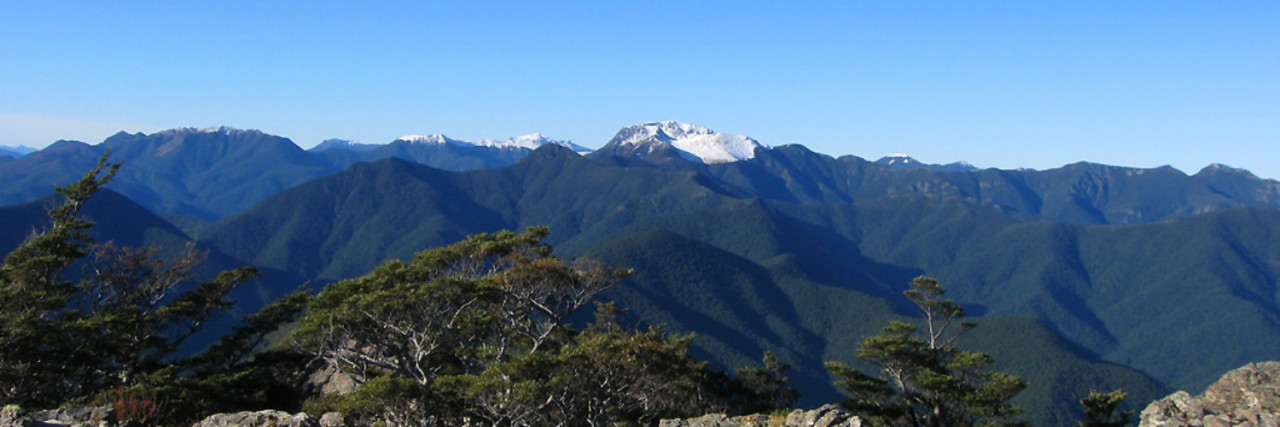
Te Araroa trail section: The landscapes here are superb, amongst the very finest along Te Araroa. The trail is rugged and, though well-marked, is unformed in places. The summits are consistently above 1,500m, often with rocky approaches.
The track has many steep, exposed sections and stream crossings. It's only suitable for fit, experienced and well-equipped trampers.
Anyone attempting the Pelorus River Track and Richmond Alpine Track together as a single section should prepare for at least a 9-day tramp, the first 3 days would be on the Pelorus River Track.
Note: the Department Of Conservation brochure available through the link on this page relates only to the northern portion of this Te Araroa section.
Hacket Junction to Hacket Hut – 1.3km, 15min (and a further 5.7km if starting from the Hacket Picnic Area carpark).
For trampers continuing on from the Pelorus River Track, Hacket Hut is a 15min walk from the signposted junction at Hacket Creek.
For those starting starting this section from the Hacket Picnic Area, about 12km from Hope up Aniseed Valley Road, it is about 5.7 km to Hacket Junction. From the picnic area carpark cross the Roding River footbridge and continue on the formed track towards Browning Hut. There is a Te Araroa direction sign after 5.7km. This is at Hacket Junction. Take the 1.3km track from here towards Hacket Hut as indicated. Alternatively, trampers can remove 20 minutes from this section by taking the first signposted track to Hacket Hut off the track up from the Hacket Picnic Area.
Hacket Hut to Starveall Hut - 6km / 4 hours
The track continues up Hacket Creek with numerous crossings. The track then departs the river and embarks on a 900m climb, initially towards Pyramid Rock, and them on towards Starveall Hut (6 bunks). The hut is located just above the tree line.
Starveall Hut to Slaty Hut - 5km / 2.5 hours
Water can be scarce between Starveall and Mid Wairoa Huts so carry at least enough to last through to the next hut and resupply point.
The track follows poles up towards Mt Starveall and summiting is an attractive possibility on fine days. The main track, however, descends into the forest and follows the ridgeline towards Slaty Peak. A sidle across the peak’s northern face brings you to Slaty Hut (6 bunks).
Slaty Hut to Old Man Hut - 10km / 5 hours
This section is predominantly above the tree line and is marked with poles. Old Man Hut (5 bunks) is located in a clearing and is accessed via a marked side trail.
Old Man Hut to Rintoul Hut - 4.5km / 5 hours
This section is rocky and exposed. It involves some scrambling and is the most difficult portion of the Richmond Alpine Track. Care needs to be taken here and trampers should be prepared to wait out adverse weather.
From the head of the Old Man Hut access track, the main track climbs through the bush and then above the bushline to the summit of Little Rintoul (1643m). It then descends very steeply on a loose surface for 250m following poles to a saddle before climbing steeply again to the summit of Mt Rintoul (1731m), the highest point on the Richmond Alpine Track. This track is very susceptible to erosion which can make for challenging walking so please take great care. Little Rintoul and Mt Rintoul should not be attempted in poor weather.
Beyond Mt Rintoul’s summit, the poled route traverses the ridgeline before dropping steeply down scree slopes to the bushline. From here a marked track leads to Rintoul Hut (6 bunks).
Rintoul Hut to Tarn Hut - 8km / 4.5 hours
The track follows a bush-clad ridge to Purple Top, the only significant open section on the route. Follow poles up and over rocks here to return to the bush. There is a sign-posted junction beyond Bishop’s Cap. The left-hand track leads to Tarn Hut (5 bunks).
Tarn Hut to Mid Wairoa Hut - 6.5km / 4 hours
The track continues along the ridge to a signposted junction before Bushy Top. Take the right-hand track from here down towards the Left Branch Wairoa River and Mid Wairoa Hut. The final descent to the river is steep. The hut is reached across the river via a swing bridge.
Mid Wairoa Hut to Top Wairoa Hut - 7km / 4.5 hours
The track from Mid Wairoa Hut follows the river. It involves a lot of sidling, at times on steep terrain, and eight river crossings. In some areas, erosion on the track presents slippery and/or narrow footholds and extreme care should be taken through here. Some trampers will find this section challenging. It should not be attempted during periods of heavy rain as the river can rise quickly.
Top Wairoa Hut to Hunters Hut - 10.5km / 5 hours
Beyond the hut, Te Araroa enters Red Hills country and a landscape transformed. The track follows markers and climbs away from the hut to a saddle at 1374m.
Beyond the saddle, the track veers northward and sidles, first on a high and exposed ridge and then westward below Mt Ellis towards another ridge. The marker poles on this section are distant but are still visible in clear weather from one to the next. Once over the ridge's shoulder, the track descends and passes through a lightly forested section.
Below the forest, the track veers southwest and down towards Motueka River Left Branch. Cross the river where marked and continue down the true right bank.
Ford the river again where marked and, from the true left side, the track climbs up towards Hunters Hut (8 bunks).
Hunters Hut opened in 1997 and is a memorial to Department of Conservation staff members Russell Griebel and Bob Waldie, both of whom died on duty when Bush Edge Hut was destroyed in a flash flood. Remnants of the old hut are still visible as you cross the river and then make the 15-minute climb up to the new hut site.
Hunters Hut to Porters Creek Hut - 9km / 4 hours
The track undulates south and crosses a number of open boulder fields and streams on its way to Porters Creek Hut (6 bunks).
Porters Creek Hut to Red Hills Hut - 10.5km / 5 hours
The track curves around to the Motueka River Right Branch and, once there, sidles above the true right bank to a crossing near the Maitland Creek confluence. The Motueka river can rise, and fall, very quickly after heavy rain. Take care in crossing and be prepared to sit it out if required. The track then climbs and sidles above Maitland Creek's true right bank towards Red Hills Hut (6 bunks), which opened late in 2009 and replaced an older hut.
Red Hills Hut to Tophouse Road – 12km / 4-5 hours
- Note: There is no water supply on this route between Red Hills Hut and SH63/St Arnaud
After Red Hills Hut, Te Araroa completes the Richmond experience on the Maitland Ridge Track - this was constructed as a MTB track by local volunteers and we are very grateful to share it with them. Take care on this route as it is used by mountain-bikers who may be moving at speed in some areas.
From Red Hills Hut an old 4WD track climbs steadily uphill to a rocky knoll at 1,050m. Go down the ridge to a broad saddle before (at times steep) climbing to a high point of 1,200m, through lovely beech forest. Then a long downhill with some zigzags that keep the gradient smooth with open patches that offer occasional spectacular views. The saddle is at 1,040m then another climb follows to the 1300m high point of the track where you have a great vantage point over the surrounding area. Finally, a steep descent (more zigzags) to the Tophouse Road.
From Tophouse Road it is 750m to SH63 then an 8km (2hr) walk on the road shoulder to St Arnaud.
There are toilets and rubbish bins available just as you arrive in St Arnaud, across the road from the school, next to the Community Hall.
Conditions
Potential Hazards
- Summits are consistently above 1,500m
- The track can be difficult and unformed at times – please take caution
- Hunting is encouraged in Mt Richmond Forest Park. All hunters must have a Department of Conservation permit. For a permit contact the Nelson Regional Visitor centre or a local Department of Conservation office.
Dogs with a Department of Conservation permit only. Contact the relevant Department of Conservation office to obtain a permit.
How to get here
Most trampers start from the Hacket road-end, 29km south of Nelson and walk through to Starveall Hut to begin the Alpine Route.
An alternate exit from the Richmond Ranges - from Tarn Hut complete the trip by descending to either Wairoa Road-end, inland from Wakefield, or to the Goulter Road-end, on the north bank of the Wairau River.
The Alpine Route is also accessible on tracks from the Goulter River or Lake Chalice.
Transport
For transport to or from Hacket Picnic Area
- Trips and Transfers Nelson Lakes and Beyond is a local transport company in St Arnaud. I can pick you up from the track end and take you into St Arnaud or to Nelson /Blenheim airports if required. Accommodation in a rural retreat (suitable for single person or a couple) available. Jennifer P: 03 539 4896 or make a transfer request online – E: kiaora@tripsandtransfers.co.nz
- Private Driver Hire P: 0272 565 643 (Paul) - can transport to/from all locations Picton-Anakiwa-Pelorus Bridge-Nelson-St Arnaud, priced on enquiry. We can collect from the Hacket carpark and drive to Nelson or to re-supply and go back in again. You will need to contact us from Starveall hut as there is no phone coverage at Hacket hut or the carpark.
- Nelson Lakes Shuttles - P: 03 547 6896 or 0275 476896 – Scheduled transfers between St Arnaud and Nelson, including destinations in Nelson Lakes National Park and stretching to Boyle Village. Prices on enquiry - E: info@nelsonlakesshuttles.co.nz.
Accommodation
Alpine Lodge St. Arnaud - Lake Rotoiti, Nelson Lakes National Park (St Arnaud Village) - E: info@alpinelodge.co.nz - P: 03 521 1869 - W: Dorm and double private rooms plus hotel rooms available. There is internet, laundry facilities, spa pool for hire, an excellent restaurant/bar/café. The Alpine Lodge can store food parcels - $15 per parcel, $20 for a large box - staying/not staying at the lodge. Alpine Lodge, 75 Main Rd, St Arnaud, RD2 Nelson 7072. (Clearly mark the parcel with "<your name>, Te Araroa Walker, eta").
Tophouse Historic Inn and Mountain View Cottages. Hotel, Motel, B&B. 68 Tophouse Road R.D.2 Saint Arnaud - P: 035211269 or 0273444027, Email: info@tophouse.kiwi. 4 double rooms in the historic Tophouse Inn B&B. and 4 Cottages self-contained with 2 double bedrooms. Meals on request and are situated 2kms from the Red Hills Beeby's Knob exit on Tophouse road. 7kms from St Arnaud and serviced by courier post for your food boxes.
Food And Supply
Track Elevation and Map

Total 2 photos. Click image above to view them all.
More information
St Arnaud
- DOC Visitor Centre - View Rd, St Arnaud - Open from 8am - P: 03 521 1806 - E: nelsonlakesvc@doc.govt.nz
- NiwaWeather - Nelson Lakes Visitor Centre
Before starting Te Araroa either as a through-walker of the whole country or a section walker, please register on Te Araroa website. Please also visit the website or download the app for detailed maps, trail alerts and other relevant information.
We encourage you to continue gaining the skills and knowledge required for a safe trip. The NZ Mountain Safety Council has lots of free resources and information you can use. These can be accessed via www.mountainsafety.org.nz.
We recommend trying these online learning tools:
Additionally, check out the range of helpful videos available from the NZ Mountain Safety Council YouTube channel.

Page last updated: Nov 29, 2023, 1:13 PM