Pureora Forest - The Timber Trail
-
Walking
-
Cycling
-
Dog Friendly
Te Araroa trail section: The Timber Trail passes through magnificent podocarp forests of rimu, tōtara, miro, mātai and kahikatea, as well as some exotic forestry and more open vegetation, offering extensive views of the surrounding landscape.
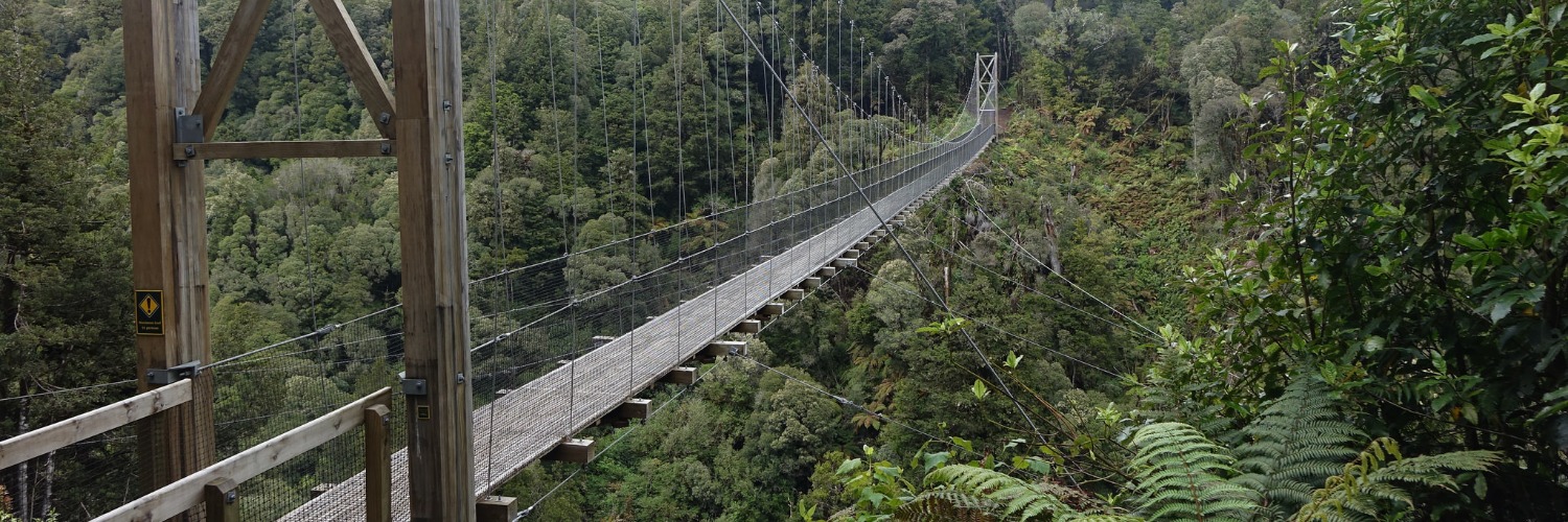
Utilising historic bush tramways, old bulldozer and haul roads, the track features 35 bridges, including 8 large suspension bridges (the longest being 141m) and showcases the historic Ōngarue Spiral, a marvel of engineering.
500m east of DOC’s Pureora Forest Headquarters is the Ngaherenga campsite, halfway between the two is the entry point to the Timber Trail.
It is recommended you plan to walk between formal accommodation locations on this route — Ngaherenga to Bog Inn Hut (20km), to Piropiro Flats campsite (18km), to #10 campsite (21km), to the campsite at the Ōngarue terminus of the Timber Trail (17km), this will take you four days. Then into Taumarunui the following day (26km). Trail surfacing is good (it is also a cycleway), so faster walkers may like to do big days. However, you should be aiming to stay at these locations.
Commence along the Timber Trail on well-graded track for approx 9km through the Pikiariki Ecological Area to the junction with The Toi Toi Track. This takes you up and over the summit of Mt Pureora (a 1hr30 deviation) to take advantage of some of the King Country’s most panoramic views of Lake Taupō, Mt Ruapehu and the Kaimanawa Ranges.
NOTICE [November 2023]: The Toi Toi track has fallen out of DOC's maintenance schedule, so it is overgrown and difficult to follow at times. The views are worth it on a good day, but this section can be easily bypassed by remaining on The Timber Trail. DOC is expected to perform some maintenance and vegetation clearance this summer. this notice will be removed when this work is done.
Descending from Pureora summit and rejoining the Timber Trail, the route again follows the cycleway to the turn-off for the Bog Inn Hut. Leave the Timber Trail here, and shortly after, a short track will lead to Bog Inn Hut for those wishing to sleep there. When leaving Bog Inn Hut, a short connecting path will put you back onto the Timber Trail, without the need to backtrack.
Heading south, you’ll soon cross the first of the spectacular suspension bridges on this route, and another shortly after. The faint of heart shouldn’t look down.
It’s largely downhill from there to bathrooms at Harrisons Rest Area, then a further 12km to Piropiro Flats campsite.
Leaving Piropiro Flats, you’ll climb through tawa and tānekaha forest to the 141m Maramataha Bridge, which will take the breath away. Further onwards, you will come to a cleared area known as ‘the terminus’, which was the most northern end of the 1950’s Ellis and Burnand tramline. There are toilets at Mystery Creek and the #11 Camp, and shortly after, you'll be at the #10 Camp, also with toilets.
From #10 Camp, it’s mostly downhill all the way, with the Mangakahukahu Bridge and remarkable Ōngarue Spiral the highlights of the day’s walk.
At Bennett Road, a campsite has been purpose-built for Te Araroa, with plenty of space to camp, a shelter and a toilet in the adjacent carpark. You should look to stay here and then walk the 26km into Taumarunui the following day. There are no appropriate locations to freedom camp en route to Taumarunui.
From Bennett Road, follow the Ngakonui-Ōngarue Road west, which runs onto the Ōngarue Back Road, which is the route towards Taumarunui, some 24km away. Just north of Taumarunui, you’ll reach a roundabout — continue straight onto Golf Road and follow it for 2.5km turning right/south onto Short Street, then left/east into Hākiaha Street (SH4), the main street of Taumarunui — a supermarket, food outlets, bank, pharmacy and more are available on this street.
Conditions
- Vehicles on the road or track
- Poisons and traps
- Forestry operations
- Small stream crossings
- Weather extremes
Seasonal restrictions
Hunters with dogs or guns may use the Timber Trail for access to the backcountry. Numbers of hunters are especially high during the stag-roaring months of March and April, and during spring (September, October and November)
Dog access
Dogs require a DOC permit. Contact the relevant DOC office to obtain a permit.
How to get here
The Timber Trail begins in Pureora Forest and is easily accessed off SH30 between Te Kūiti and Mangakino.
The central part of the trail can be accessed from Piropiro campsite at the end of Kokomiko Road, Waimiha, and from Ōngarue, via SH4 at the southern end. There is highway signage near Pureora and Ōngarue to direct riders to the ends of the trail.
Transport
Accommodation
- DOC huts in the Pureora Forest Park
Bog Inn Hut — 4 bunks, mattresses and heating — Topo50 maps — Grid reference: NZTM2000, E1828988, N5726201
Note: Hut tickets must be purchased from DOC offices prior to your tramp.
- Timber Trail Lodge — located adjacent to the Trail at Piropiro — P: 0800 8856343 — E: stay@timbertraillodge.co.nz — Dorm and private accommodation, including dinner and breakfast.
- Camp Epic — is located at the 40km marker on the Timber Trail. Tent site and glamping accommodation options. Communal kitchen/dining and the best hot showers in NZ. Breakfast is included in your stay. Ph 0220237958
Taumarunui
- Taumarunui Holiday Park - 100 State Highway 4, South, Taumarunui P: 07 895 9345 - E: taumarunui-holiday-park@xtra.co.nz
- Grandads Cottage - 298 Miro St, Manunui — P: 078957358 — E: grandadscottage298@gmail.com Budget accommodation, camping, internet available.
- Kellys Motel - 10 River Rd, Taumarunui - P: 0800 554000 or 07 8958175 - E: stay@kellysmotel.co.nz
Alexender Spa Motels - Check-out time 10am, 50 metres to RSA and restaurants, 14 Studio and 2 Family Studio Units. 6 Marae Street Taumaranui
Forgotten World Adventures Motel — is directly across the road from New World, the BP, McDonalds and Pizza store in Taumarunui. The number is 0800 7245 2278
Food And Supply
Track Elevation and Map


Total 2 photos. Click image above to view them all.
More information
Before starting Te Araroa either as a through-walker of the whole country or a section walker, please register on Te Araroa website. Please also visit the website or download the app for detailed maps, trail alerts and other relevant information.
We encourage you to continue gaining the skills and knowledge required for a safe trip. The NZ Mountain Safety Council has lots of free resources and information you can use. These can be accessed via www.mountainsafety.org.nz.
We recommend trying these online learning tools:
Additionally, check out the range of helpful videos available from the NZ Mountain Safety Council YouTube channel.

Page last updated: Nov 30, 2023, 11:20 AM