
Kāpiti Coast
-
Walking
Te Araroa section: An easy day’s walking after the rigours of Tararua tramping. The trail is virtually level walking for the whole 22km, taking in some of the Kāpiti District’s icons – the Waikanae River, an estuary and scientific reserve, Kāpiti Island in full view from the beach, Queen Elizabeth Park, and the distinctive cafes and local art outlets in Paraparaumu, Raumati and Paekākāriki.
Waikanae River - 4.5km / 1¼hr
From the Waikanae Bridge, take the track down the river on the true right bank (north).
Follow the main track downstream for 4.5km. Pass a footbridge over the river and continue under the expressway. Cross the second footbridge towards the Otaihanga Domain.
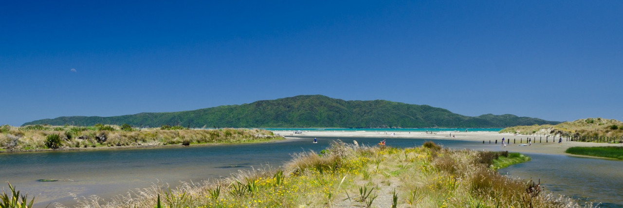
Otaihanga, Estuary and Scientific Reserve — 2.5km / ½hr
Exit bridge into Otaihanga Domain. Immediately turn sharp right on the river side of the toilets. Follow the true left bank (south side).
After 500m, veer left to the boardwalk and track through the Waikanae Estuary Scientific Reserve.
Ignore side tracks. After 15 minutes, join an older section of the Reserve Track that exits onto Manly Street.
Turn right and follow the grass verge for 5min, skirting the lagoons. Just before the houses, turn right, leaving the verge to enter another section of the Waikanae Estuary Scientific Reserve.
Follow boardwalks over the swamp, sand dunes and onto the beach.
Paraparaumu Beach to Raumati South — 8.5km / 3hr
At the beach, turn left (south) by yellow Marine Reserve triangles. Weather and tide permitting, keep on the beach heading south for 8km.
Walking along the beach is safe and accessible right to Queen Elizabeth Park except in extremely high tides; in this case, use local roads running parallel to the beach. All major streams are bridged.
You can divert to cafes near high-rise apartments at the boat launch area.
At the end of Raumati South Beach, turn inland through piles of driftwood, where you see a triangular “Total Fire Ban” sign. Continue for a short distance, then turn right onto the Coastal Track.
Queen Elizabeth Park — 3.5km / 1½hr
Follow the undulating Coastal Track — the one nearest to the sea — for about 1.5km to the picnic and toilet area. Turn left (inland) onto a sealed road for 100m.
Turn right at the next road intersection and follow another 100m before rejoining the coastal track.
In August 2018, the Coastal Track at Raumati South was closed due to coastal erosion. The alternatives are:
- Continue along the beach at low tide
- Continue on the Coastal Track at your own risk,
- or use the alternative Inland Track. Follow a track uphill to the north briefly. This soon joins up with the Inland Track. Head along this, down a hill and join a major sealed track. Turn right (south), and a short distance along, turn right onto a small track signposted “Coastal Track 900 metres”. This takes you back onto the Coastal Track — continue as above.
At the end of the Coastal Track, cross the small Wainui Stream and continue along the beach until you see a large building, the Surf Life Saving Club, on your left. A little way past this, head up onto the north end of The Parade. An alternative is to use the road bridge 100m upstream and cross a field on the right to the Surf Life Saving Club.
Paekākāriki - 2km / ½hr
Continue along The Parade for 1.7km, then turn left into Beach Road, Paekākāriki’s main street.
Cross over the pedestrian crossing to the right-hand side of the road and head past the shops toward the railway lines.
Conditions
Potential hazards
- Vehicles on road or track
- Tides, waves & rivers - safer at low tide . Will need to walk along road in certain conditions
- Small stream crossings
- Track exposed to sun, wind or cold
- Do not be tempted to take a short cut through the Waikanae Estuary, the sand can be very soft and dangerous at low tide
How to get here
Northern Start: Waikanae River Bridge, SH1
Southern End: Beach Road, Paekakariki
Transport
Paraparaumu & Paekākāriki - Getting to/from the track
The track starts and finishes on State Highway 1 so care needs to be taken if being dropped off by car. There are suitable parking areas at both ends.
A regular train service from Wellington to Waikanae (The Kāpiti Line), stops at Waikanae, Paraparaumu and Paekākāriki.
Accommodation
Paraparaumu
- Marie Bismarck is a "Trail Angel" living near the Trail at Paraparaumu Beach and offers camping, water, shower for Te Araroa walkers. E: mariebismarck@gmail.com
Paekākāriki
- Paekākāriki Holiday Park - 180 Wellington Rd, Paekākāriki - P: 04 292 8292
- Te Araroa walkers will always be welcome at Paekakariki Holiday Park. The website may require 2 nights for booking, but that is not the case. No advance bookings necessary as long as you show up before reception closes at 7pm.
- Belvedere Motel - Cnr Paekākāriki Hill Rd and SH1 - P: 04 292 8478 - E: belvedere.motel@xtra.co.nz
- Finn’s Hotel - 2 Beach Rd, Paekākāriki - P: 04 292 8081 - E: finnskapiti@xtra.co.nz
- Paekākāriki Beachfront B&B - 136 The Parade, Paekākāriki - P: 04 905 8595 - E: info@paekakarikibnb.co.nz
- Fergus and Nicky offer a secluded, dry sleepout at 136 Tilley Road, Paekakariki. Laundry, bathroom etc. facilities and meals. Hikers are also welcome to leave their stuff while they walk to the next stop - e.g. Wellington - and then take the train back and stay for a second night before catching the ferry - E: nzfwheeler@gmail.com
Food And Supply
Paekākāriki
- Paekākāriki Village Grocery Store - 11 Beach Rd, Paekākāriki Village - P: 04 292 8020 - open 7 days
Track Elevation and Map


Total 3 photos. Click image above to view them all.
More information
Before starting Te Araroa either as a through-walker of the whole country or a section walker, please register on Te Araroa website. Please also visit the website or download the app for detailed maps, trail alerts and other relevant information.
We encourage you to continue gaining the skills and knowledge required for a safe trip. The NZ Mountain Safety Council has lots of free resources and information you can use. These can be accessed via www.mountainsafety.org.nz.
We recommend trying these online learning tools:
Additionally, check out the range of helpful videos available from the NZ Mountain Safety Council YouTube channel.

Page last updated: Jan 15, 2024, 4:23 PM