
Cullen Brynderwyn Walkway
-
Walking
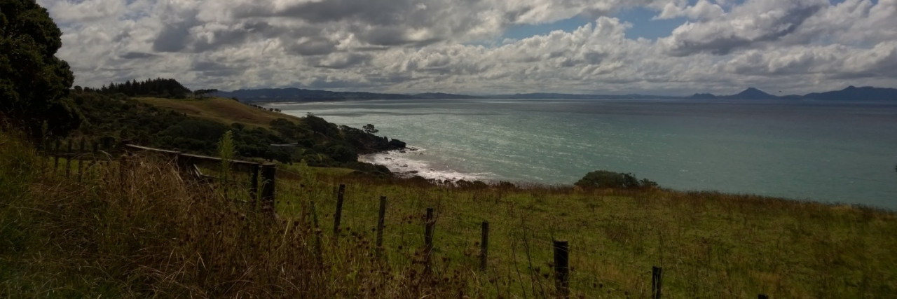
Te Araroa section: This day walk is a mixture of sealed road, 4WD track and Department of Conservation bushwalk. Ascending 297 metres, it offers views of the surrounding landscape in every direction.
From the junction with Cove Road (km 420.5), follow Cullen Road uphill for 7.5km. The road changes from sealed to 4WD track (at about the 4km mark) and eventually intercepts DOC’s Brynderwyn Walkway (a graded farm track).
- Note — there may be forestry harvest traffic on Cullen Road, generally operating Mon-Fri (and occasional Saturdays) 5am-4pm. Please observe any signage and traffic management instruction, particularly when tree-chopping is taking place near the road. We recommend you wear a hi-viz vest and/or pack covers. The private track on the topographical map at the top of Ruru Way is not a shortcut up to Cullen Road from the campsite. You will be asked to turn around.
Turn east and follow the Department of Conservation’s Brynderwyn Walkway (on Langsview track). You walk toward a highpoint of 297m and a trig at 276m for magnificent views in every direction.
Before the trig, pass through a kissing gate on the left and follow the marked track downhill. The track becomes a gravel 4WD and then a concrete driveway. Please follow the marked route, including the short bushwalk, turning off the concrete driveway, on your right as you near Cove Road (this is part of the access agreement). You will end up in the DOC carpark on Cove Rd.
Conditions
Potential hazards
- Vehicles on road or track
- Poisons & traps
- Farming operations
- Forestry operations
- Small stream crossings in paddock?
- Few water sources
No dogs allowed.
How to get here
Northern Start: Corner Cove and Cullen Roads, Waipū
Southern End: Carpark at junction of Cove and Bream Tail Roads
Transport
Accommodation
Brynderwyns
- DragonSpell Retreat - Cullen Rd, Waipu (look for the signs at the very end of Cullen Rd, 7.5km up from Cove Rd) - P: 0275077750 - E: cosmickali@gmail.com
- Waorahi Camping, Waorahi Conservation have generously provided a free camping area with water and toilet. This is situated at km 430, part way along The Brynderwyn ridge, and is just off the DOC track.
Mangawhai Heads
- Mangawhai Lodge - 4 Heather St, Mangawhai Heads - P: 09 431 5311 - E: info@seaviewlodge.co.nz
- Mangawhai Backpackers - Coastal Cow, is at 299 Molesworth Dr, Mangawhai Heads - P: 09 431 5246 - E: mangawhaibackpackers@gmail.com
- Mangawhai Heads Motel or Camping Ground, Mangawhai Heads Rd, Mangawhai Heads - P: 09 431 4675
- Mangawhai Camping - We have a basic cottage and tenting with water, electricity and toilet in our small orchard at Mangawhai village, close to Shops and Food. Donation of $10pp appreciated. Call first please on Oh too wun 796 496. Your hosts - Mark and Kerry
Food And Supply
Track Elevation and Map

Total 1 photos. Click image above to view them all.
More information
Before starting Te Araroa either as a through-walker of the whole country or a section walker, please register on Te Araroa website. Please also visit the website or download the app for detailed maps, trail alerts and other relevant information.
We encourage you to continue gaining the skills and knowledge required for a safe trip. The NZ Mountain Safety Council has lots of free resources and information you can use. These can be accessed via www.mountainsafety.org.nz.
We recommend trying these online learning tools:
Additionally, check out the range of helpful videos available from the NZ Mountain Safety Council YouTube channel.

Page last updated: Oct 3, 2023, 7:13 PM